A Vision for NERRS: Partnerships for the Coast
Through a variety of carefully selected sites from around the country, the National Estuarine Research Reserve System helps preserve significant estuarine environments. The 27 areas that make up the network are protected for long-term research, water-quality monitoring, education, and coastal stewardship.
- Introduction
- Research is the Foundation
- Education Teamwork
- Scientific Stewardship
- Science-based Decision Making
- Conclusion
The National Estuarine Research Reserve System (NERRS) was created as a partnership program between NOAA and the coastal states. Today, the 27 estuarine reserves work together and with their coastal states to bring national-scale value, while supporting local and regional program needs.
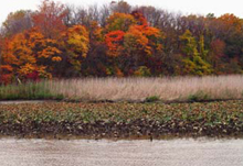
The sites within the estuarine reserve system protect over one million acres of land and water. Sites range in size from 365,000-acre Kachemak Bay, Alaska to 571-acre Old Woman Creek, in Erie County, Ohio—shown here.
Since Congress mandated establishment of the reserve network in 1972, NERRS has grown as a prime example of a visionary federal-state partnership program. As officials look ahead over the next few decades, they are confident that the spirit behind robust national programs in research, education, and stewardship will continue to advance the NERRS mission “to practice and promote coastal and estuarine stewardship through innovative research and education, using a system of protected areas.”
The major challenge facing the system is how to address increasing population and development pressures that threaten the health and integrity of estuarine systems. The reserve program has plans but few resources to enhance research and monitoring capabilities, establish new and more effective education and learning programs, and build on stewardship opportunities beyond the boundaries of the reserves themselves. To ensure the reserves do not become isolated islands in the face of these pressures, NERRS officials are looking to build upon the strong culture of teamwork that is the hallmark of the program. By expanding existing partnerships and building new partnerships with other federal, state, local, and private entities, NOAA will support local and state programs and help to protect these valuable environmental areas.
Despite increasingly limited resources, growing expectations for NERRS remain. This article describes how NERRS plans to meet increasing demands by developing partnerships to conduct cutting-edge research and build exciting education and training programs over the coming years.
Research is the Foundation
The core of all NERRS national programs is research and monitoring. In the future, NOAA will work to expand efforts to collect, integrate, and deliver important environmental data. The reserves will continue to grow in importance for visiting and resident scientists and for the Graduate Research Fellows funded by NOAA to conduct their studies in the reserves.
Integration of System-wide Monitoring Program Data
The System-wide Monitoring Program (SWMP), a collaborative effort to track long-term changes in estuarine ecosystems and coastal watersheds, has expanded from water quality and weather data to monitoring of biological factors like emergent and submerged aquatic vegetation and watershed and land use changes.
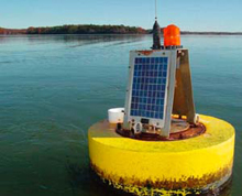
Buoys such as this one are part of the System Wide Monitoring Program and help to provide a steady stream of data needed to support improved coastal management decisions.
As SWMP started its second decade in operation in 2006, it became a crucial element in the developing Integrated Ocean Observing System (IOOS). IOOS is a multi-agency network of federal and regional coastal and ocean observing systems designed to expand our ability to collect, deliver, and use ocean information.
In 2006, reserves began telemetering water quality and weather data from their monitoring stations, in partnership with NOAA's National Weather Service. Reserves’ environmental data are collected at 15-minute intervals, uploaded to the Geostationary Operational Environmental Satellites System, and transmitted to the Hydrometeorological Automated Data System. Data can be viewed online within minutes of transmission.
The addition of estuarine water and weather data to the growing mix of available information will greatly enhance the accuracy of local weather and flooding forecasts. In the decades ahead, other near-real time data users will include commercial and recreational fishermen, mariners, emergency responders, researchers, and resource managers.
To support and encourage additional data users, the monitoring program is expected to expand to continue building out its existing emergent/submerged aquatic vegetation biomonitoring and estuarine habitat mapping programs to include the monitoring of invasive species, sediment contaminants, nekton, plankton, and benthos (bottom-dwelling) spatial and temporal community diversity, as well as changes in marsh bird communities. Additional monitoring of the impacts of climate change and sea level rise on estuarine habitats over time will continue to be a focus of the NERRS programs. New partnerships with NOAA’s National Water Level Observation Network and National Geodetic Survey will expand the system’s capability to monitor coastal hazards and climate change and assess coastal resiliency.
Research Partnerships
In the future, expanded current and anticipated planned partnerships between NERRS and NOAA’s National Centers for Coastal Ocean Sciences, Center for Operational Oceanographic Products and Services, the Coastal Services Center, and the National Geodetic Survey will help improve data products for coastal managers and other user groups. These products will include integrated assessments, forecasting models, climate models, habitat elevation changes, and robust geographic information system layers to monitor coastal development impacts on estuarine habitat.
In an effort to coordinate expertise and resources as well as to increase efficient use of research funds, NERRS will seek to team with a variety of other entities such as Sea Grant, the National Marine Sanctuaries Program, the U.S. Environmental Protection Agency’s National Estuaries Program, the U.S. Geological Survey, and the National Science Foundation.
These additional partnerships will provide opportunities to expand research activities at the reserves to include studies of coastal ecosystem resiliency, restoration project impacts, and social sciences, not only in the reserves themselves but also in their watersheds. Research will continue to form the foundation for coastal education, training, and restoration programs.
Education Teamwork

Around 200 students celebrated National Estuaries Day at the U.S. Department of Commerce on October 3, 2002. Students participated in fish printing, tours of the National Aquarium, presentations by naturalists, and EstuaryLive.
The NERRS education program is one of only four dedicated education programs in NOAA; the others include the National Marine Sanctuary Program, Sea Grant, and Coral programs. Many reserves already offer programs for K-12 students; teacher training and development; curriculum development; and special programs like EstuaryLive, a virtual field trip to estuaries broadcast directly into classrooms over the Internet. The success of these programs is a strong indication that estuarine science is an important component of Earth System Science curriculum nationwide.
The goal for future NERRS education programs is to develop educational products that ensure a place for estuarine science in environmental studies, biology, mathematics, physics, and other Earth system sciences at all levels of K-12 education. Already, NERRS education coordinators are developing the K-12 Estuarine Education Program (KEEP), a leading-edge effort to develop relevant curricula and lesson plans, make optimal use of the data generated by the System-wide Monitoring Program, and establish teacher training programs. Achieving that goal requires full integration into educational tools and reforms that are being developed now. NERRS will work to correlate national efforts with states, which are leading the way in educational change. Preliminary studies are currently being conducted to see just how the NERRS education program fits into the larger picture of education reform.
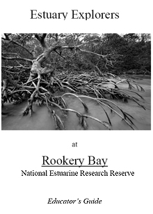
To help teachers and students understand more about amazing coastal resources, NERRS has developed innovative educational materials such as this educator’s guide focusing on Rookery Bay NERR, which is considered to be one of the few remaining relatively pristine mangrove estuaries in the United States.
The NERRS education program is taking a scientific approach to designing, implementing, and delivering education products. For example, in the summer of 2006, a nationwide needs assessment was conducted to understand how real-time data are used by teachers. The results of the survey will help NERRS address course content and help define how the SWMP data will be used to teach estuarine science in the classroom. As a result, KEEP will develop on the leading edge of science education, serving students and teachers, as well as ensuring knowledge and appreciation of estuarine science, and developing the next generation of coastal scientists and decision makers.
Efforts such as these will continue in the future, helping to ensure that estuarine science is integrated into classrooms nationwide.
Scientific Stewardship
Stewardship has always been an important part of the NERRS mission. The NERRS strategic plan defines stewardship as “the responsible management of coastal resources using the best available information for the purpose of maintaining and restoring healthy, productive, and resilient ecosystems.” In the tradition of the NERRS federal-state partnership, stewardship efforts have been designed and implemented at each reserve to meet local needs, and that will continue. While for most reserves stewardship efforts have meant restoration projects, these efforts have led to an overall greater, more sophisticated understanding of restoration science and the importance of regional coordination.
The vision for future NERRS stewardship efforts includes a greater role for regional collaboration, with a goal that the reserves will be regional catalysts for restoration priorities related to reserve habitats. A key to this goal is the growing research and monitoring efforts at the reserves, which will bring together multiple NOAA capabilities, including water-level monitoring, habitat mapping, and land-use change monitoring, as well as habitat restoration initiatives.
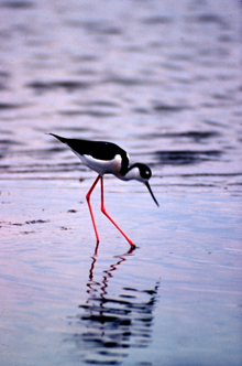
Within ACE Basin National Estuarine Research Reserve, 45 miles south of Charleston, South Carolina, a black-necked stilt hunts for its dinner.
Restoration needs are not confined by statutory boundaries, and partnerships are evolving now to develop stewardship opportunities that addresses regional issues. Reserves often team up with other local entities, including National Wildlife Refuges, to carry out restoration projects that not only benefit lands managed by multiple agencies but also establish benchmarks for future restoration efforts.
Additional partnerships are foreseen with agencies outside NOAA, including the U.S. Fish and Wildlife Service, National Park Service, Environmental Protection Agency, and others, as well as broader community engagement, using science, education, and outreach to help the public and decision makers improve the use and development of coastal habitats.
Science-based Decision Making
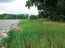
One of the more successful programs at the Chesapeake Bay Virginia NERR in 2005 was a workshop targeting marine contractors and consultants on “green” alternatives to shoreline protection measures.
One of the reserve system’s newest national programs, the Coastal Training Program (CTP), is poised to become increasingly important in the decades ahead as a growing coastal population puts more and more pressure on natural systems and human community infrastructures. CTP targets local and regional decision makers such as elected and appointed officials, land developers, non-governmental agencies, landscape and real estate professionals, ecotourism operators, and others. Through the program, decision makers receive up-to-date, science-based training in topics of local interest, including watershed management, resource management, green buildings, invasive species control, and understanding regulations and ordinances.
The expansion of monitoring, stewardship, and education programs through strategic partnerships will result in the CTP becoming more robust in terms of its ability to respond to the diverse needs of coastal managers as well as in the content of training programs. For example, CTP is already collaborating with Ohio Sea Grant to sponsor a Coastal Training Program that will cover the entire Ohio Lake Erie shoreline.
Conclusion
With their cutting edge research and monitoring capacities, the reserves are protected living laboratories and classrooms that will provide the educational and scientific foundation to help NOAA achieve its goal to protect, restore, and manage coastal ecosystems. In the coming years, NERRS will continue this work with added emphasis on increased collaboration within NOAA, with other federal agencies, and with the local communities around the reserves to increase stewardship, help coastal managers apply science to the decision-making process, improve educational programs, and expand research and monitoring capabilities.
