Directions to the Party
For nearly 200 years, NOAA’s National Geodetic Survey has defined and managed the National Spatial Reference System—a consistent coordinate system that defines latitude, longitude, height, scale, gravity, orientation, and shoreline throughout the United States. At the center of this system is a national network of precisely located, permanently marked, in-the-ground survey marks.

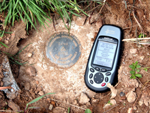
Hundreds of thousands of survey marks, such as this one, are scattered throughout the United States, set by the National Geodetic Survey and its predecessor organizations, including the U.S. Coast and Geodetic Survey. Click image for larger view.
Have you ever had trouble preparing clear and complete directions to a birthday party or backyard BBQ? Don’t remember if it is a left turn or a right turn at the fourth or fifth traffic light across from the old gas station that is now a fruit stand? Well, the U.S. Coast and Geodetic Survey (C&GS) has been preparing travel directions for almost 200 years and can help…
The Foundation: A Network of Survey Marks
Since the early 1800s, C&GS has worked to establish a network of precisely located, permanently marked, in-the-ground survey marks. There are literally hundreds of thousands of these permanent survey marks or monuments scattered throughout the United States. The marks are still in use today and each mark provides one or more types of accurate data.
Today, the National Geodetic Survey (NGS) maintains a database with information on approximately 1,200,000 survey disks, set all over the United States and its possessions. This network of precisely placed survey marks is the set of reference points used by engineers, surveyors, and others interested in precise positioning on the Earth’s surface.
The network is also the foundation for creating those party directions…
Mark Descriptions
Each C&GS survey mark has a unique description that includes detailed directions in a standardized format on how to reach the mark from a well-known point. These instructions are important because surveyors, engineers, and others who need to set up survey equipment over the survey mark must be able to find the mark. Early marks were often on top of hills or even on top of mountains and sometimes in quite remote areas, so clear directions on how to travel to the mark were very important.

This survey mark from Massachusetts was first set in 1934. For “horizontal control marks” such as this one, the primary data available are latitude and longitude, although elevation data are available for some horizontal control marks as well.
The original USC&GS Special Publication No. 247, Manual of Geodetic Triangulation defines that: "A description must be clear, concise, and complete. It should enable one to go with certainty to the immediate vicinity of the mark, and by the measured distances to reference points and the description of the character of the mark, it should inform the searcher of the exact location of the mark and make its identification certain. It should include only essential details of a permanent character."
NGS still follows these guidelines, so that a person with a minimal background in surveying and no local geographic or historical knowledge of an area can easily find the mark by logically following the text of the description.
The “To Reach”
Even though many of the survey marks were in very remote locations, the “To Reach” portion of the mark description enabled members of a survey party to travel directly to the survey mark with minimal time lost searching for the mark. The “To Reach” has a defined format that includes the names of all roads and the distances and directions to travel on each road to reach the final destination (the survey mark).
The standard “To Reach” conforms to the following format:
- Start from a well-defined point, such as a U.S. Post Office in the nearest town or the intersection of major highways and the approximate location of that intersection. Example: “From the intersection of Interstate 111 and U.S. Route 222 about 3 miles east of Centerville…”
- State the highway to travel on by name and/or number and the direction to travel. Example: “Go north on U.S. Route 222…”
- State the distance to travel on that route and state the next landmark. Example: “Travel for 3.2 miles to an intersection...”
- State the action to take at that next landmark and the next direction of travel. Example: “Turn right on Smith Road and go east…”
- State the distance on that next route and the next landmark. Example: “Go 1.4 miles to a dirt road…”
- Continue repeating the steps until the destination is reached.

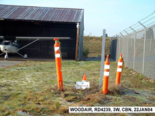
What a typical, newer station looks like in its “natural” habitat, and what you might encounter if you follow those “To Reach” directions to the end. Click image for larger view.
Odometer distances are given to tenths of kilometers (followed by tenths of miles). For roads with names and numbers, both are provided in the first occurrence. Other conventions are defined for giving directions as well. For example, if a road goes due east, the word "EAST" is used; if the road wanders in a general easterly direction, the word "EASTERLY" is used instead. Intermediate references are used if the distance becomes longer than about five miles. The place at the end of truck (or car) travel is typically mentioned. If walking is required, the approximate time required for packing is included in the description as well. If travel to the station is by boat, the place of landing is stated.
Standard Format
The format for the first leg of the "To Reach" is:
i. FROM THE MAIN POST OFFICE IN DOWNTOWN SMITHVILLE, or
FROM THE INTERSECTION OF INTERSTATE XX AND STATE HIGHWAY YY, ABOUT 4.8 KM (3 MILES) NORTH OF SMITHVILLE;
ii. GO A DIRECTION (north, northeast, northerly, northeasterly, etc.);
iii. ON A ROAD (name or number of road or highway);
iv. FOR A DISTANCE (km followed by miles in parentheses);
v. TO SOMETHING (intersection, or fork in road, or T-road left or T-road right).
B. The format for all other legs of the “To Reach” is:
i. TURN LEFT OR RIGHT, OR TAKE RIGHT OR LEFT FORK, OR CONTINUE STRAIGHT AHEAD;
ii.GO A DIRECTION (north, northeast, northerly, northeasterly, etc.),
iii. ON ROAD (name of road or highway);
iv. FOR A DISTANCE (km followed by miles in parentheses);
v. TO SOMETHING (intersection, or fork in road, or side-road left or right, or station on left or right).
All five parts of each leg are included in each "To Reach" description.
The Final Directions
So how do the directions look when completed? Here’s a sample:
"TO REACH THE STATION FROM THE INTERSECTION OF INTERSTATE 300 AND MAIN STREET (STATE HIGHWAY 101) IN JONESVILLE, GO EASTERLY ON HIGHWAY 101 FOR 3.7 KM (2.3 MILES) TO AN INTERSECTION. TURN RIGHT AND GO SOUTH ON MILLER ROAD FOR 5.1 KM (3.2 MILES) TO A SIDE-ROAD RIGHT. CONTINUE SOUTH ON MILLER ROAD FOR 6.6 KM (4.1 MILES) TO AN INTERSECTION. TURN LEFT AND GO EASTERLY ON SMITH ROAD FOR 2.4 KM (1.5 MILES) TO STATION ON THE LEFT IN THE FENCE LINE."

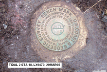
This survey mark, first set in 1917, is a bench mark, meaning it marks a point whose elevation above or below a geodetic vertical datum is known. Bench marks are just one type of survey mark set by the National Geodetic Survey and its predecessor organizations. Click image for larger view.
To find a National Geodetic Survey mark description on line, go to the NGS Datasheet Web page. From this page, you can search by any of the “Retrieval Methods” provided. If the mark’s name is entered, you will also need to select the state where the mark is located.
To obtain the distances and directions needed to develop the “to reach” (or your party directions), drive to a well-known point, like the intersection of two major highways (or an interstate exit) and use that as the starting point for the “to reach.” Then, use the format above and measure the distances with the car’s odometer and the directions from a map or compass. Write each piece of information down as it is collected so that the information does not get recorded incorrectly or out of order. When complete, have someone check the entire “to reach” by driving the route and seeing if he or she arrives at the desired destination.
If the survey party can find their survey mark, your party attendees should be able to find the party using the same instructions!
Contributed by Commander George E. Leigh, NOAA Corps (Ret'd.)
