The Recovery
The National Geodetic Survey (NGS) and its predecessor agencies have set permanent survey marks throughout the United States. NGS maintains a database with precise data about each survey mark's horizontal and/or vertical position, defined by latitude, longitude, and height coordinates. NGS connects these marks together in a network called the National Spatial Reference System.

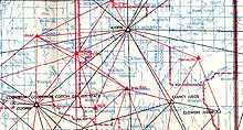
This map is called a triangulation diagram and it shows the location of survey marks. The triangles on the map show how the marks were surveyed.
The story below is told by NGS surveyor George Leigh, recounting in his own words his experience in recovering a survey mark in 1987, in preparation for a resurvey of a portion of Oklahoma.
The farmer told me that the original government surveyors arrived at his farm in a covered wagon! This was the beginning of a very interesting mark recovery in the ancient mountains of southwest Oklahoma.
Station ALDEN was needed for a global positioning system (GPS) project designed to upgrade the quality of survey control in southwest Oklahoma. Consequently, the station, located on Bally Mountain, needed to be recovered. After studying the triangulation diagram and the quad maps, I traveled to the farm house on the northern slope of Bally Mountain.
The farmer's wife answered the back door, and after I explained who I was and what needed to be done, she invited me in for lemonade.

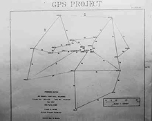
Progress sketch of GPS survey, Fort Sill, Oklahoma, May, 1987. A progress sketch is prepared to show the location of survey marks in the project that had been surveyed and how they were interconnected.
Her husband knew about the survey mark and said he remembered the mark being set when he was a young boy. I challenged his memory and asked him to tell me what year the mark had been set (I had the description in hand). He was only three years off: he guessed 1918, and it was actually set in 1921. He then proceeded to tell the story...
The government surveyors arrived in a covered wagon pulled by horses. The surveyors needed permission to set a mark, a place to park their wagon, a place to graze their horses, and food for themselves. The farmer's mother and the surveyors reached an agreement where, for a price, they would set up their wagon at the foot of the mountain, would graze their horses in one of the farm's pastures, and the farm would supply fresh milk and eggs every morning. The surveyors stayed for several days.

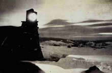
The "flashing lights" seen by the locals were actually electric lights used at night. The lights provided a target which would be sighted upon by an observer with a survey instrument many miles away.
The local gossip was all about some "government men" flashing lights between hills tops for nights on end! The farmer also recalled a second visit many years later (probably in 1934, when the disk was reset), how he was gone during the war years, and then another visit shortly after the war (1947).
The lemonade was good, the story was better, and the mark was there – a great day in the field!
Contributed by George Leigh, NOAA's National Ocean Service
