Forecasting Fire Weather
The NOAA National Weather Service’s Incident Meteorologists include a group of about 70 scientists specially trained to go to wildfires and other incidents and provide weather briefings and forecasts to incident responders and command staff. Provided forecasts ensure the safety of operations, allowing responders to take into account of the most changeable aspects of any incident—the weather.
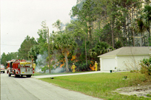
Firefighters at an wildland-urban interface. Fires burning close to people are becoming an increasing concern as people build more homes in and near forested land.
We’ve seen it on the news—dry conditions and a wayward spark are the start of engulfing flames, wildfires that threaten homes and sweep across the landscape. And oftentimes, we hear how shifting winds or other weather phenomena are impacting decisions and the ability of firefighters to control a blaze. The weather is one of the most changeable aspects of any incident, and in factoring the weather, incident responders have turned to NOAA’s National Weather Service for over 90 years.
Today, there are about 70 Incident Meteorologists (IMETs) within NOAA who travel to incidents, bringing their expertise as well as the backing of the entire National Weather Service. This group’s beginnings date back to the early 1900s and the group has grown ever since.
The History of the IMET Program
The catastrophic fires of 1910 that raged across Idaho, Montana, and Washington, were a turning point in how the nation dealt with wildland fires. Prior to 1910, there was no real concerted effort to manage or control the nation’s forests or fight forest fires. The death and devastation left behind by the 1910 wildfires made people take notice, and the U.S. Forest Service was soon tasked with managing the nation’s forests and fighting forest fires. Forest Service employees soon realized that the weather was a major factor in how and when fires could be fought, and so they turned to the experts at the U.S. Weather Bureau, the predecessor to the National Weather Service.
“Mobile” Fire Weather Units
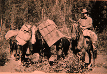
IMETs preparing to travel to a fire camp, circa 1920. Click image for larger view.
The Weather Bureau started doing forecasts specifically for the fire weather community in 1914. In 1916, the first “mobile” weather unit was deployed to a fire. This mobile unit consisted of a forecaster and a team of horses carrying his weather equipment to the field to support firefighters. It soon became apparent that having a forecaster at the incident was a big plus for both planning and safety.
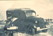
IMETs preparing a Fire Weather Forecast for a wildfire incident, circa 1930. Click image for larger view.
In the 1930s, the first mobile fire weather vans were created. Automobiles had proven reliable and could carry more equipment farther and with less upkeep than a team of horses. Fire weather “vehicles” were used all the way into the 1970s, with upgrades of vehicles and radios as they became available.
The Boise Interagency Fire Center
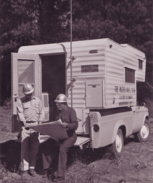
IMET Chuck Syverson briefs a wildland fire manager from a National Weather Service mobile unit in 1965. Click image for larger view.
In 1965, the Forest Service and the Bureau of Land Management developed the Boise Interagency Fire Center (BIFC) to better coordinate firefighting efforts in the Great Basin area of the U.S. Shortly thereafter, the Weather Service joined the group and created a “Staff Meteorologist” position to support decision making at the BIFC and to streamline the IMET program nationwide.
In 1993, the BIFC changed its name to the National Interagency Fire Center (NIFC), to better reflect the national scope of its mission.
The Air Transportable Meteorological Unit
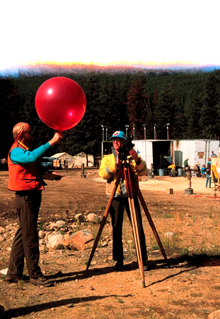
IMET Carl Gorski prepares to track a Pilot Balloon (PIBAL) at a fire incident as a Fire Behavior Analyst prepares to launch the PIBAL.
In the 1980s, the Weather Service realized that there were better ways to support the IMET program. While fire weather vans had worked in the past, there were problems with this system. Only a handful of vans were available, meaning that only a few IMETs were available for dispatch. Weather support on an incident was critical, and while the demand for IMETs was increasing, the supply of IMETs and weather vans was staying the same. Also, incidents were taking place in increasingly remote areas of the country. Not only did the Weather Service need more IMETs, it also needed to be able to get these IMETs and their equipment to remote areas quickly.
The first step in addressing these issues was to scale down the size of the equipment, so it could be more easily transported. Thus, the first Air Transportable Meteorological Unit (ATMU) was born. The ATMU was a trailer filled with needed equipment, which could be towed or flown into incident areas. The only drawback to this approach was that the trailers were expensive, and they were just barely able to be transported via helicopter.
The Advanced Technology Meteorological Unit
In the early 1990s, technology had advanced enough that the first laptop computers were used in the field, bringing equipment down to a more manageable size. Also, equipment for satellite communications had “shrunken” to a size that was practical for use in a mobile weather unit. This marked the creation of the new Advanced Technology Meteorological Unit. For the first time, IMETs were able to travel literally anywhere that a vehicle or helicopter could take them and, equally important, all the equipment needed to run a small “weather office” could come along for the ride.
The IMET Program Today
Today, the main incidents IMETs cover are wildfires, though IMETs have responded to other types of incidents such as oil and chemical spills and terrorism response drills. IMETs were on the scene when the New Clarissa tanker spilled oil off the coast of Oregon, helped in recovering debris from the Space Shuttle Columbia in Texas, and provided forecasts for emergency responders in the event of a terrorist attack at the 2004 Democratic and Republican National Conventions. Most recently, the IMET program has assisted with forecast and warning support for the Federal Emergency Management Agency after the Greensburg, Kansas EF5 tornado in May 2007.
Tools of the Trade
Today, IMETs have the ability to set up “mini-Weather Forecast Offices” at any site across the nation. In 2007, satellite communications were upgraded to use a two-way system that consists of a small, portable satellite dish, about the size of a laptop, with a receiver and a transmitter. This allows IMETs to download weather data from the Internet nearly anywhere in the world. The new All Hazards Meteorological Response System (AMRS) now weighs in at around 50 pounds, a far cry from the old days of horses or vans.
Laptops used by IMETs have also been upgraded. IMETs in the field now use a software package that mimics the software used in Weather Forecast Offices. IMETs use one program to look at model data, satellite data, radar data, sounder data, lightning data, and surface and upper air observation data. This allows IMETs to work with data in real time, thus shaving precious minutes off any weather alerts that may affect an incident.
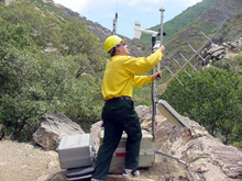
IMET Chuck Redman from the NOAA National Weather Service forecast office in Boise, Idaho, setting up the FireRAWS equipment near a wildfire.
The ATMU was also changed in 2002. The new ATMU—now called the “Atmospheric Theodolite Meteorological Unit”—fits in one case and consists of the theodolite and Pilot Balloon equipment used by IMETs to launch and measure weather balloons on site. These balloons allow IMETs to take upper air observations at an incident, in order to determine what the winds at the location might do later in the day.
A special unit within the Bureau of Land Management dispatches, sites, and maintains the Remote Automated Weather System (RAWS). RAWS provides IMETs with crucial information, including temperature, humidity, and wind speed and direction. However, unlike earlier systems, RAWS has better computing capabilities; can take readings on fuel moisture and precipitation; and can radio its observations to a satellite, after which the observations can be downloaded and added to the RAWS network.
Training
IMETs are National Weather Service meteorologists who have completed specialized, intensive training. Before being selected as an IMET trainee, each meteorologist must have completed training on synoptic and meso-scale forecasting, radar and satellite interpretation, NOAA policy, and other topics needed to become qualified as a “journeyman forecaster.”
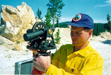
NOAA forecaster Troy Lindquist of the NOAA National Weather Service forecast office in Grand Junction, Colorado, uses a theodolite to align the angle a weather balloon takes after being launched.
IMET certification requires the completion of several more fire-weather specific courses and several on-site training dispatches. Trainees learn about everything from the Incident Command System to how a fire reacts to certain weather, fuel, and topographic conditions. Trainees must also learn about micro- and meso-scale forecasting for fire weather. Trainees must also prove that they can perform all the duties required of them during an incident. This “proof” comes during trainee dispatches to wildfires, under the tutelage of a certified IMET.
Once a trainee has completed all of these tasks, he or she is then certified as an IMET. By the time a trainee becomes certified, he or she will have completed, at a minimum, over 225 hours of fire weather and behavior training as well as on-the-job training.
In order to remain certified, all IMETs must take 25 hours of refresher training each year or go to an incident every 18 months.
Future Directions
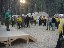
A weather briefing at fire camp.
The IMET program has a long history of excellence in incident response. The IMETs are a unique group, uniquely qualified and knowledgeable, able to respond to any incident, anywhere in the U.S. In the coming years, the program will continue to evolve. The use of fine grids of data, embedded within larger National Weather Service forecast grids, will allow IMETs to provide responders with greater detail about the weather and allow for better forecasting of where a hazard will move next. Improving technology will also allow IMETs to deliver information to responders more quickly.
After the September 11th terrorist attacks, the world changed in many ways, including increased emphasis on response to terrorism and other hazards. IMETs have always responded to incidents other than wildfires. However, as we move ahead, the role of IMETs in all-hazards response will only increase.
