World Ocean Database
Overview and Use
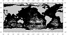
Dark areas of the ocean indicate the geographic distribution of vertical profiles for the Ocean Station Data Set, one of 11 that make up the World Ocean Database. Click image for larger view.
Since its inception in 1961, NOAA’s National Oceanographic Data Center has archived data leading to creation of the World Ocean Database beginning in 1998. This database is the world’s largest collection of vertical profile1 data of ocean characteristics available internationally without restriction. Eleven data sets, each based generally on the type or types of instrument(s) used to collect the data profiles, make up this enormous set of ocean measurements.
The World Ocean Database is global in scope and quality-controlled for scientific use with all data and metadata in one common format. The scientific communities that study ocean and climate need research-quality ocean profile data sets that the World Ocean Database provides to understand, describe, and predict the temporal and spatial variability of physical, chemical, and biological parameters in the ocean. In addition, operational forecasting centers use such data sets from the database to perform quality control of real-time oceanographic data. The World Ocean Database has enjoyed widespread use by the international scientific community.
In 1974, NOAA scientists began processing data from the National Oceanographic Data Center to produce the Climatological Atlas of the World Ocean, first published in 1982 by the NOAA Geophysical Fluid Dynamics Laboratory. This digital and paper atlas provided the scientific community with a set of objectively analyzed temperature, salinity, and oxygen data at 33 standard depth levels in the world ocean. It has been cited over 2,400 times in the refereed scientific literature. It would be nearly impossible to develop these kinds of atlas products for the world science community without NOAA's world ocean data sets. Since 1974, there have been numerous versions of these oceanographic data sets including the World Ocean Atlas 94 and then the World Ocean Database 1998 and subsequent editions in 2001 and 2005.
Data Come from Everywhere!
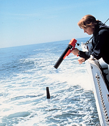
Launching an expendable bathythermograph, also known as an XBT, from the NOAA ship McArthur. These instruments measure ocean temperature. An XBT data set is one 11 data sets in the World Ocean Database. Click image for larger view.
The profiles in this database are derived from sensors deployed on different types of instruments that measure various ocean characteristics in the water column at discrete geographic locations in the ocean. The World Ocean Database 2005 contains data from more than 164,000 ocean cruises made by 93 countries. Data have been gathered from 6,900 ships, numerous offshore structures, moored buoys, undulating drifting floats such as those that are part of the ARGO system, expendable bathythermographs (also known as XBTs), conductivity-temperature-depth instruments (also known as CTDs), and others. Some data even come from elephant seals that have had temperature-depth measuring devices attached to them! The data in the 2005 edition of the World Ocean Database represent the labor of thousands of individuals working sometimes in extreme conditions over a 150-year period.
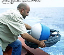
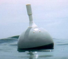
Deploying a drifter buoy. These buoys provide uniform quality control of sea surface temperature required by climate prediction models as well as data on currents, atmospheric pressure, winds, and salinity. Satellites track the buoys' positions. The World Ocean Database includes a data set of ocean characteristics collected by drifting buoys. Click images for larger views.
Data have been acquired from throughout the World Ocean and all of its marginal seas, from the tropics to under the ice cap at the North Pole and to the shores of Antarctica. Data include measurements from throughout the water column to a maximum depth of 10,892 m (35,735 ft) in the Mariana Trench, only a few meters less than the deepest point in the ocean. The World Ocean Database 2005 contains data from 7.9 million temperature profiles and 2.4 million salinity profiles in addition to data from oxygen and nutrient profiles. Since publishing the 2001 edition of the World Ocean Database, the National Ocean Data Center has added 900,000 temperature profiles along with many modern and historical data sets for all of the other parameters in the database.
Data Variables
World Ocean Database 2005 contains data for 28 variables including ocean tracers, such as freons and other chemicals. The Ocean Station Data and low-resolution Conductivity-Temperature-Depth data set, one of 11 in World Ocean Database 2005, has 24 variables including a large number of the most frequently measured in situ physical (temperature, salinity), chemical (dissolved gases, carbon variables, nutrients, tracers), and biological (total chlorophyll and plankton) historical oceanographic observations. Data are available both online and on digital media. The online data are presorted by 10-degree geographic square areas and by year. They are also available by user-specified criteria.
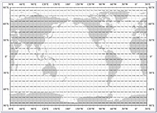
Users can access the World Ocean Database by pre-sorted ten-degree geographic areas as shown here, by year, or by building their own queries by position coordinates, observation dates, data set, measured variables, and other parameters. Click image for larger view.
Variables in the Oceanographic Station Data and low-resolution Conductivity-Temperature-Depth data set are:
- Temperature [t]
- Salinity [S]
- Dissolved oxygen [O2]
- Phosphate [HPO4-2]
- Silicate [Si(OH)4]
- Nitrate [NO3]
- pH [pH]
- Total chlorophyll [Chl]
- Total alkalinity [TALK]
- Partial pressure of carbon dioxide [pCO2]
- Dissolved inorganic carbon [DIC]
- Tritium [3H]
- Helium [He]
- Delta helium-3 [D3He]
- Delta carbon-14 [D14C]
- Delta carbon-13 [D13C]
- Argon [Ar]
- Neon [Ne]
- Chlorofluorocarbon-11 [CFC-11]
- Chlorofluorocarbon-12 [CFC-12]
- Chlorofluorocarbon-113 [CFC-113]
- Delta oxygen-18 [(D18O]
- Pressure [P]
- Plankton taxonomy and biomass
Each data record for an oceanographic station may contain simultaneous profiles of one or more of these variables as a function of depth or pressure. Online users can extract data both at observed depths and up to 33 standard depth levels. The observed depth values are the measurements as a function of depth or pressure submitted by the data originator. The profiles at standard depth levels are the measurements submitted by the data originator that are estimated for selected depths. The profiles include quality control flags for observed and standard depth level data.
Worldwide Value of the Database
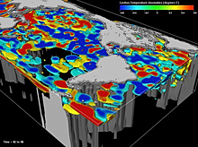
Real-world observation of major ocean variables like temperature data from the World Ocean Database, shown here, help ocean and climate scientists to develop theoretical models to further study ocean temperature anomalies. Click image for larger view.
The National Oceanographic Data Center's attempts to make the World Ocean Database as complete as possible through data archaeology and rescue projects and by incorporating modern data has allowed scientists to execute scientific studies not previously thought possible. This includes producing the first estimates of the time series of the global integral of ocean heat content beginning in 1955 and the gyre and basin scale variability of salinity since 1955. This database has allowed scientists to produce 50-year assimilations of ocean profile data that are of great value for understanding the role of the ocean as part of Earth’s climate system.
1. A profile is a set of measurements for a single variable (such as temperature or dissolved oyxgen) at discrete depths taken as a sampling instrument drops or rises vertically in the water column.


