NOAA Implements Improved Tools for Forecasting Water Levels and Currents
People who work, live, and play along the nation’s coasts need accurate information on water levels and currents. For example, knowledge of high or low water-level conditions, or the ebb and flood direction of currents, is critical to commercial shippers, search and rescue operations, oil spill response, and recreational boaters. Users not only want to know what the present conditions are, but also what the conditions will be like in the near future. To meet these needs, NOAA has developed improved tools: Operational Coastal Forecast Systems.
Past Forecasting Tools
For over 200 years, NOAA has provided valuable information on currents and water levels using astronomic predictions in a tide-table format. Starting in the early 1990s, this information was complemented with the introduction of real-time observation data. Although extremely valuable, both of these information products have limitations. For example, both are provided only at a few locations in most ports and harbors; real-time observations do not extend into the future; and astronomic predictions do not incorporate the effects of important processes such as winds, barometric pressure changes, and river discharges.
Operational Coastal Forecast Systems

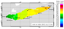
Example operational water level forecasts for Lake Erie during a strong winter storm event. In this image, Buffalo, New York, is predicted to experience high water levels (orange color), while Toledo, Ohio, is predicted to experience low water levels (green color). Click image for larger view.
Starting in 1997, NOAA began radically enhancing the capability of water-level and current information through the technology of “Operational Coastal Forecast Systems.” These systems combine the best of existing technology (e.g., astronomic tide predictions and real-time data) along with exciting new tools such as hydrodynamic models. This process has required the transition of hydrodynamic models from the research environment into a 24/7 operational environment.
Operational Coastal Forecast Systems provide nowcasts (for present conditions) and forecast guidance products (for future conditions) that are generated by a three-dimensional hydrodynamic model. The models vary slightly by location, but generally use information including real‑time data, astronomic predictions and forecast guidance winds, water levels, and other weather parameters to predict variables such as water levels, currents, salinity, and temperatures at thousands of locations across a body of water.

Example forecast of surface currents in a channel region of New York Harbor. Currents moving faster than one knot are shown in yellow, red, and pink. Click image for larger view.
Key products resulting from these forecasts include data plots and animated maps of water levels, water currents, salinity, and water temperatures. Typically, the nowcast conditions are updated hourly, while the forecast guidance component performs 30-hour forecasts, four times a day (e.g., every six hours).
Presently, Operational Forecast Systems have been developed for nine water bodies, including the Chesapeake Bay, New York Harbor, Galveston Bay, St. Johns River, and all five of the Great Lakes. Eventually, NOAA intends to provide Operational Coastal Forecast coverage for the nation’s entire coastline.
Conclusion
NOAA has been able to combine valuable existing tools with the new technology of hydrodynamic models to form Operational Coastal Forecast Systems. Products from these systems are delivered by the Internet to provide the nation with the best possible forecasts of water levels, currents, and other important parameters.
In addition to improving the safety and efficiency of commercial shipping and recreational boating, other direct applications of this information include: improving national security; proactively preventing, mitigating, and responding to natural hazards and oil spills; facilitating safe, efficient, and quality recreational use of coastal waters; aiding search-and-rescue, forensic, and law-enforcement operations; improving coastal storm warnings; facilitating coastal management and stewardship; and providing research opportunities.
Related Web Sites
Operational Coastal Forecast System
Center for Operational Oceanographic Products and Services
