Harnessing Information - The Future Role of Coastal Oceanography
NOAA collects, analyzes, and distributes historical and real-time observations and predictions of water levels, coastal currents, and other oceanographic and weather data. Our ability to make the best decisions possible, whether for the safety and efficiency of maritime commerce, the protection of life and property from hazardous events, the restoration of coastal habitat, or the wise management of the coastal zone all rely on having a comprehensive understanding of the physical oceanography that drives much of our coastal processes.
- Introduction
- Integrating Observations
- Increasing Safety and Preparedness
- Forecasting Future Conditions
- Applying Data over the Long Haul
- Conclusion
The behavior and condition of the coastal ocean and land boundaries influence virtually every aspect of human activity. Most of the problems and opportunities of interest to the nation require knowledge of physical, geological, chemical, and biological aspects of this environment.
No one has found a way to control the behavior of the oceans or the havoc they can wreak on coastal communities. So far, the only means of minimizing the devastation is through information. The ability to monitor, observe, and forecast coastal events is critical to maintaining the health, safety, and economic vitality of coastal communities.
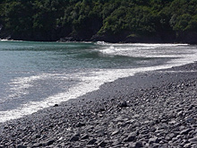
The daily rise and fall of tides impacts all coastal areas. Click image for larger view.
Fluctuations in sea level, including the daily rise and fall of tides, are key to understanding our oceans and coasts. NOAA has been monitoring tides since the 1800s. Tidal data and the resulting tidal currents have always been intricately linked to the vitality of our nation’s economy, ensuring that ships carrying goods are able to navigate our waterways safely. This information is also used in coastal engineering projects, tsunami and storm surge warnings, and long-term ocean and climate research.
The next two decades will bring an increased focus for NOAA on integrating tide data with data and observations of physical, geological, chemical, and biological aspects of the coastal environment. Information integration will help to protect coastal communities, as well as improve marine navigation safety and reduce the risks to the coastal environment resulting from increased marine commerce.
Integrating Oceanographic Observations
As NOAA forges ahead, integrating oceanographic observations with many other types of data from many sources to allow effective, innovative tools and solutions to improve the quality of American life will continue to be a priority. NOAA will accomplish this in close partnership with other federal agencies, the private sector, state and local governments, and the general public, and will aim to be the partner of choice by all those working in this area of science.
Improved management of coastal ecosystems, providing the mariner with a clearer picture of potential dangers that can threaten navigation safety, and providing coastal communities with increased response times when facing major storms, all require easy access to an integrated data-sharing system with superior quality assurance that provides real-time oceanographic observations and long-term measurements on watersheds and coastal waters. The ability to integrate data, information services, and applied products will improve the management of the nation’s coastal resources.
The National Water Level Program is a network of short- and long-term water level stations and is an “end-to-end” system of data collection, quality control, data management, and product delivery. At the heart of this program is the National Water Level Observation Network (NWLON).
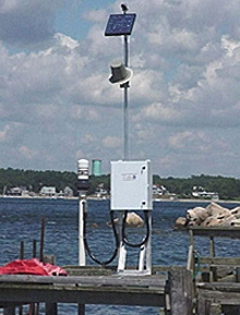
This water level station at Gray Gables, Massachusetts, is part of the National Water Level Program. The station includes a data collection platform, acoustic sensor with a protective tube, satellite antenna, various meteorological sensors, and a solar panel to keep the station battery charged.
During 2007, the 200th NWLON station will be established. The NWLON, a backbone of the Integrated Ocean Observing System, requires measurements at 300 locations to provide the adequate spatial coverage needed to provide a nucleus around which regional cooperative water level stations can be integrated.
NWLON stations are also equipped with other physical oceanographic and meteorological sensors. A new “non-contact” microwave water level sensor will be integrated into the NWLON that will reduce maintenance costs. All NWLON stations will disseminate quality-controlled, real-time data that provide a national baseline for the Physical Oceanographic Real Time System or “PORTS®.”
Currently, PORTS® are operated in 13 locations around the U.S. Nineteen PORTS® installations will be operational by the end of 2007. PORTS® provides quality-controlled, real-time data from a suite of “off-the-shelf” sensors such as water level, currents, salinity, air-gap (bridge clearance), air and water temperature, wind speed and direction, barometric pressure, and other parameters, at multiple locations within a close geographic area. These data are made available via telephone, the Internet, and other means.
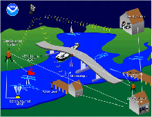
PORTS® provides real-time data and other navigation products to promote safe navigation for ships. This drawing shows the inter-relationship among the different components of the system. Click image for larger view.
In the future, a wave observation capability will be integrated into the PORTS® suite of sensors. High frequency radar to map surface currents will also be integrated into PORTS® as a powerful new tool.
A quick-response capacity allows first responders access to tide, current, wave, and other data when there is a natural disaster, Homeland Security event, search and rescue scenario, or hazardous material spill. This capacity consists of a suite of sensors providing information on water levels, currents, waves, and meteorology and equipped with real-time communication technology, enabling first responders to receive critical information.
Increasing Maritime Safety and Coastal Community Preparedness
Maritime navigation plays a key role in the vitality of our economy. Over 98 percent of the nation’s cargo passes through the top 150 U.S. seaports. Maritime accidents, which are costly to the economy and environment, are on the rise as the volume of maritime commerce and the size of ships passing through harbors continue to increase. To meet the challenges of promoting safe and efficient navigation within U.S. waters, while protecting valuable marine ecosystems, NOAA provides real-time oceanographic data and other navigation products.
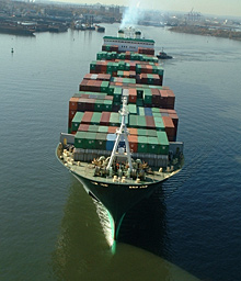
Mariners on cargo ships like this one rely on water level information to advantageously time their approach to and exit from ports. Click image for larger view.
For those seaports whose real-time data needs are not met by the existing water level station network, NOAA works in partnership with the local community to install PORTS®. NOAA’s PORTS® is already improving marine navigation and coastal resource management. The real-time tide and current data provided through PORTS®, for example, can be combined with nautical charts and precise positioning information to provide the mariner with a clear picture of the potential dangers that may threaten navigation safety.
With so much at stake, NOAA’s role in observing, forecasting, and warning of environmental events is expanding. Hurricanes, tornadoes, floods, and other severe weather events cause an average of $11 billion in damages every year to the U.S. economy. Reduced risk of marine accidents and oil spills, better search and rescue capabilities, and other efficiencies derived from improved information and services could be worth more than $300 million a year along the nation’s coasts.Forecasting Future Conditions
Scientists use computer simulations, or models, to study large-scale processes that they cannot manipulate in “real-life” or in a laboratory setting. Scientists try to incorporate as much data as possible, to build a computer replication of the environment that is as realistic as possible.
Nowcasts and forecasts are scientific predictions about the present and future states of water levels and other physical oceanographic parameters in a coastal area. Presently, NOAA operates nine Operational Forecast Systems (OFS).
The future of OFS lies in providing high-resolution, numerical hydrodynamic models that are based on nowcasts and forecasts of water levels, currents, waves, water temperature, and salinity in 44 major water bodies. For each water body and for each selected parameter, the OFS will reliably produce and disseminate quality-controlled hourly nowcasts (24 times per day) and 0-30 hour forecasts (four times per day).
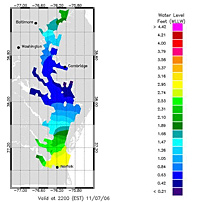
This water level nowcast image was created from the latest Chesapeake Bay Operational Forecast System nowcasts for Chesapeake Bay. The nowcasts are for the most recent water surface elevations in the Bay, as simulated by the model when forced by recent observations of coastal water levels and winds. Click image for larger view.
The OFS products will be integrated with NOAA’s tidal predictions and observations, providing enhanced spatial resolution and accurate forecasts that extend (0-30 hours into the future) beyond real-time observations.
User-driven requirements have also identified the need for various types of ecological forecasting model systems, such as forecasts of harmful algal blooms. The physical conditions necessary for specific adverse environmental events such as a harmful algal bloom or an oil spill drift will be identified, forecasts of conditions will be prepared and compared to actual conditions, and user/customer groups will be contacted to assess and enhance the utility of such forecasts.
Ecological forecast models will provide a range of benefits, such as protecting public health by allowing advance closure of shell fisheries and other stocks and more efficiently managing marine resources.
Climate - Applying Data over the Long Haul
In addition to real-time water level information, there is a need for easily accessible long-term environmental observations.
We live in a highly variable climate system, with conditions changing over the span of seasons, years, decades, and longer. Given stresses such as population growth, drought, increased demand for fresh water, and emergent infectious diseases, decision makers need a reliable structure and process for receiving accurate, timely, relevant climate information. These data will allow them to manage resources to maximize the benefits and minimize the impacts of climate variations. Better science enhances the protection of life and property by providing better information on extreme changes in climate.
Conclusion
Easy access to an integrated data-sharing system is key to improving management of coastal ecosystems, alerting mariners of potential navigational dangers, and providing coastal communities with increased response times when facing major storms.
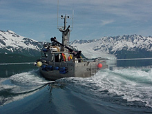
NOAA will continue to provide real-time oceanographic data and other navigation products to promote safe and efficient navigation within U.S. waters. Click image for larger view.
The future requires the ongoing implementation of observation and prediction systems based on the real-time measurement of physical properties and processes that lead to environmental forecasts useful for ecosystem protection, resource management, and human safety. The future calls for linking compatible site-specific and regional monitoring activities with an integrated synthesis capacity to improve the utility and comparability of all existing sources of data. The future demands the provision of one-stop electronic access to all integrated environmental measurements.
