The Future National Spatial Reference System
The National Spatial Reference System (NSRS) is a consistent, national coordinate system that specifies latitude, longitude, height, scale, gravity, and shoreline throughout the nation. NOAA’s National Geodetic Survey defines and manages this coordinate system, which provides the foundation for mapping, charting, and a multitude of scientific and engineering applications.
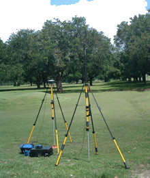
With global positioning system (GPS) technology, a survey that once took days or weeks can now be completed in a few hours, with 10 to 100 times more accuracy. GPS satellites beam signals in real time to GPS receivers, like the one shown here, revealing their coordinates—where they are in space at any given time. Click image for larger view.
For nearly 200 years, NOAA’s National Geodetic Survey (NGS) has defined and managed the National Spatial Reference System (NSRS)—a consistent coordinate system that defines latitude, longitude, height, scale, gravity, orientation, and shoreline throughout the United States. A consistent and accurate NSRS is critical for transportation, navigation, and communication systems; land record systems; mapping and charting efforts; and defense operations.
The NSRS is the set of reference points used by surveyors, geodesists, and others interested in precise positioning on the Earth’s surface. Today, the NSRS consists of:
- a network of precisely located, permanently marked, in-the-ground geodetic reference points;
- a national network of global positioning system-enabled Continuously Operating Reference Stations (CORS), which supports three-dimensional positioning activities;
- a consistent, accurate, and up-to-date national shoreline based on long-term water-level observations, which is used to develop nautical charts and aids accurate modeling of storm surge, coastal flooding, and pollution movements;
- a set of accurate models that describe dynamic, geophysical processes that affect these spatial measurements, such as land subsidence (sinking) and uplift and movement of the Earth’s crust; and
- an accurate model of the Earth’s gravity field.
For almost 200 years, NGS and its predecessor agencies have maintained these various components of our nation’s NSRS. This story takes a brief look at today’s NSRS and considers the exciting possibilities in defining the NSRS that will likely evolve over the next 20 years.
The Horizontal and Vertical Datums
The primary tool for establishing the NSRS has been datums, or mathematically defined systems that provide internally consistent geodetic coordinates. Two main datums make up the National Spatial Reference System—the horizontal datum and the vertical datum.
The Horizontal Datum
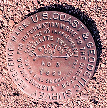
Brass monuments permanently affixed in concrete or surrounding bedrock indicate accurate geodetic reference positions within the National Geodetic Survey's horizontal and/or vertical datums. Click image for larger view.
A horizontal datum is a mathematically defined grid of lines of equal latitude and longitude which has been developed through the collection of specific points on the Earth whose latitude (or north-south location) and longitude (east-west location) have been accurately surveyed within the datum. In 1983, NGS "connected" all of the existing horizontal survey marks or monuments together and created the North American Datum of 1983 (NAD 83). This datum is the official horizontal datum to be used by federal agencies.
The Vertical Datum
The vertical datum is a mathematically defined surface to which heights refer and that has been determined using a collection of specific points on the Earth with known heights. This surface is often near, but not generally coincident with, mean sea level. Near coastal areas, mean sea level is determined with a tide gauge. In 1929, NGS compiled all of the existing vertical monuments and created the National Geodetic Vertical Datum of 1929 (NGVD 29).Since then, movements of the Earth's crust changed the elevations of many monuments. In 1988, NGVD 29 was adjusted to remove inaccuracies and to correct distortions. The new datum, called the North American Vertical Datum of 1988 (NAVD 88), is the official vertical datum to be used by federal agencies today. The official “datum origin point” for the NAVD 88 is the Father Point tide gauge on the Saint Lawrence River in Quebec, Canada.
The Future NSRS - Same Mission, Different Tools
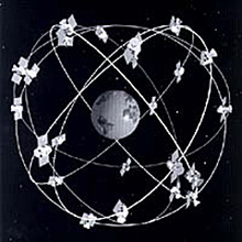
The orbiting constellation of GPS satellites.
Over the past 20 years, GPS has provided a revolutionary new approach for defining and providing access to the NSRS. For the first time, fast and accurate three-dimensional coordinates (i.e., latitude, longitude, and elevation) relative to a global (not just nationwide) frame of reference were achievable without requiring line-of-sight connections between survey points.
In the next 20 years, the NSRS will be defined by improvements in four areas: expanded application of datum transformation tools, changes in the CORS, improvements in the geoid model, and wide-spread adoption of digital nautical charts. Incorporating these upgrades into the future NSRS will minimize the need for passive survey marks in the ground.
VDatum—A New Datum Transformation Tool
Elevation data for the coastal zone are essential for answering critical questions about erosion, wetland restoration, habitat conservation, land management, and smart growth. But coastal elevation data come from diverse sources and frequently have different vertical references. Data might be referenced to land-based benchmarks (elevation marks in the ground), tide gauges, or GPS satellites.
To combine or compare coastal elevations (heights and depths) from diverse sources, they must be referenced to the same vertical datum as a common framework. Using inconsistent datums can cause artificial discontinuities that become problematic when producing maps at the accuracy required for informed decisions about the coastal zone.
To address this problem, NOAA’s National Ocean Service recently created a new datum transformation software tool called “VDatum.” This tool allows elevations in one datum to be converted to another datum. VDatum can transform coastal elevations between 28 different vertical datums.
VDatum is now available for seven coastal regions and for many applications and technologies, including storm surge and coastal inundation models, tsunami research, shoreline mapping, coastline change analysis, sea level rise impacts, ecosystem resource management, navigation services, disaster mitigation planning, and many others.
In the future, many more coastal regions, including the Southern Chesapeake Bay, Maryland; Southern California; Pensacola, Florida region; and the Gulf of Maine, will be covered by the VDatum tool.
Continuously Operating Reference Stations (CORS)
Complementing the space-based GPS system is a growing nationwide network of continuously operating GPS reference stations called CORS. CORS is a network of hundreds of stationary, permanent GPS ground stations that provide position information (e.g., latitude, longitude, and height), 24 hours a day, seven days a week. This information will be updated at a variety of intervals—from hours to milliseconds.
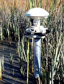
This continuously operating GPS reference station, part of CORS, determines accurate elevations quickly, inexpensively, and in places where traditional methods are impractical, such as this marsh.
The CORS network is now a major component of NOAA’s National Spatial Reference System that complements the system of survey marks. Working around the clock, CORS stations continuously receive GPS radio signals and integrate their positional data into the National Spatial Reference System.
NGS is the manager of CORS data, but the federal government is neither the owner nor the operator of the system. CORS has been a cooperative effort, but it has grown unevenly in terms of the distribution of reference stations across the nation, as well as the type of sites represented.
In order to address this problem, NOAA will work to establish a base of CORS around the U.S. that are operated by the federal government. This federally operated “foundation” network will be built and monitored carefully with well-known positions, velocities, and possibly seasonal variations. The base network will be integrated with all CORS, to build a comprehensive network to support three-dimensional positioning activities. However, because NGS will maintain and operate stations in key locations, there will not be any risk of stations being inactivated or disabled in such a way that coverage is compromised.
Also, in the future, data from the U.S. government-operated “foundation” CORS will be included in the International Earth Rotation Service Terrestrial Reference Frame (ITRF). The ITRF is the global horizontal datum. Inclusion of CORS data in the ITRF will ensure that the datum of the United States is consistent with that of other countries.
The Geoid
In 1990, NGS introduced a “geoid” model that represents the difference between GPS-determined geometric heights and gravity-related heights. NGS continues to improve the geoid model, using satellites and other airborne platforms to measure Earth’s gravity field in even greater detail and incorporating these data into the geoid model.
The determination of orthometric heights (i.e., heights above the geoid) from GPS will rely essentially on the combined accuracy of GPS-derived ellipsoid heights and a gravity-based geoid model. In this way, absolute heights could be determined at any point on the Earth’s surface that can access GPS signals. Control surveys requiring highly accurate local heights generally do not require absolute accuracy at the millimeter level, but rather require local height difference accuracies of that magnitude.
In the not too distant future, a control surveyor will be able to establish an absolute height mark to a few centimeters of absolute accuracy (using CORS and a gravity-based geoid model), and then distribute accurate local height differences relative to that mark through traditional geodetic leveling techniques. This will save hours, even days, of field work and thus have a huge economic impact on surveyors.
The National Shoreline
In the future, coastal mapping will be rapid and highly-automated, using integrated GPS and inertial measurement unit (IMU) technology to directly geo-referenced satellite data. Currently, humans must trace the shape of the shoreline from aerial photographs—a time-intensive effort. Using this new technology, computers, not humans, will identify the shoreline in digital images.
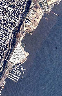
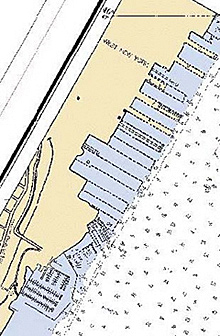
Left is a high-altitude aerial photography of Hudson River, New York. The same area is shown on a NOAA nautical chart on the right. Comparing these sources, created at different times, provides information on the rate of change in the coastal zone, which aids in the design of coastal zone mapping projects. Click images for larger views.
Conclusion
Prior to the 1980s, the NSRS was established and improved using traditional surveying techniques that have existed for centuries. With the advent of space-based technologies, including GPS and remote sensing satellites, the entire approach to defining and accessing the NSRS has and will continue to change into the future.
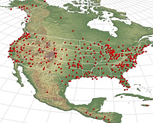
Continuously Operating Reference Stations coverage in the United States as of October 2006. Click image for larger view.
The use of passive monuments is no longer practical as the primary means of defining and accessing datums. There will always be some need for passive monuments (for example, to provide control in areas where GPS signals cannot be received or to provide a backup system in the event of a catastrophic GPS failure). However, in the future, NGS is not planning on expanding the already deteriorating network of passive points.
NGS has already begun to transform the definition and access of geodetic datums from the old philosophy of “passive marks in the ground” to the new philosophy of “virtual monuments in the sky.” GPS satellites are tracked and their orbital positions are now known to within one to two centimeters. In contrast, the many passive survey marks placed in the ground over the past 200 years are often lost or disturbed and their motions are generally not tracked.
This leads to a strangely counterintuitive conclusion: We know more about the position of satellites 20,000 kilometers away from Earth than about the survey marks on the ground at our feet. In the future, the predominant portion of our positioning will be done relative to satellites, and not passive marks in the ground.
Contributed by Dr. Dru A. Smith, NOAA’s National Ocean Service
