Visions
NOAA’s long voyage of the past two centuries has been challenging and inspiring. The last three decades have been truly revolutionary. But where are we headed? In Visions, we explore the challenges and opportunities of the next 20 years and offer a glimpse into NOAA’s future.
Looking Ahead
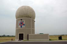
The next step in NOAA's long-time research and advancement of weather radars is phased array radar. Using electronic controls of beams and frequencies, these new radars can scan more quickly, thereby increasing lead times for tornado warnings.
Two hundred years ago, could Thomas Jefferson have known what he started, how the founding of the nation’s first science agency—the Survey of the Coast—would have blossomed into an organization that covers all corners of the globe and touches our oceans, coasts, and skies?
We know where we’ve been, but where are we going? In 20 years, what will NOAA look like? No one knows for certain…and herein lies science’s fun and intrigue. Through inquiry and exploration, the scientists of NOAA will likely unravel mysteries, build new technologies to tackle new challenges, and expand understanding of our planet in ways that are beyond our imagination. However, it is always fun to think about the possibilities…
Where will be our new ports-of-call? What new challenges and opportunities lie beyond the horizon? We know change will continue to accelerate, but how? These were questions we posed to our offices and staff. Their answers are many and varied, reflecting our own diversity and breadth. Here, we share a few excerpts as we peer into the looking glass.
NOAA Aircraft
Today, NOAA’s fleet of aircraft play a key role in making observations and acquiring data to better understand the natural Earth system. An emerging new technology could change the face of NOAA’s aircraft fleet and help us reach new heights in understanding and predicting the world in which we live:
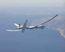
Unmanned Aircraft Systems, such as the Altair platform shown here, can help scientists collect data from otherwise inaccessible areas.
“NOAA scientists are realizing that Unmanned Aerial Systems (UAS) have the potential to take measurements in areas that are currently unmonitored due to airplane and pilot limitations and could provide research and operational activities in these hard-to-reach environments more accurately, more economically, and with less risk involved.” (from: The Future of NOAA Aircraft: Going Where No Man Can Go)
Climate Research
NOAA scientists continually strive to understand and describe climate variability and change to enhance society's capacity to anticipate and respond to climate change. In the next 20 years, fundamental, long-term research on a broad range of global change issues will remain a high NOAA priority, with a few new additions:
“Integration of research across existing disciplines is a central theme of NOAA’s future climate research. The links among the land, ocean, polar ice, atmosphere, and biosphere must be further explored, bolstering our nascent understanding of the complex interrelationships that comprise the global climate system.
A glimpse into the global observation system of the future might reveal:
Networks of data buoys distributed over the oceans that would provide a wide range of surface and sub-surface ocean data, such as sea surface temperatures and waves. In addition to providing data for climate assessments, information from these buoys would serve as early detectors of tsunamis.” (from: The Future of Climate Research)
Remote sensing
Remote sensing is the science of obtaining information about objects or areas from a distance, typically (although not always) from aircraft or spacecraft. As a leader in the rapidly-evolving field of remote sensing, we will continue to seek and refine ways to deliver remote sensing data and products to all users:
“The future of remote sensing lies in making numerous types of accurate, current, and high-resolution remotely sensed data and derived geospatial information products readily available for every area of interest.
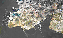
Digital aerial photography showing devastation in Ocean Springs, Mississippi. This imagery was acquired by NOAA on August 30, 2005, one day after Hurricane Katrina slammed the region.
Perhaps the most exciting area of remote sensing research at NOAA is multisensor data fusion. The merging, or fusion, of remotely sensed data collected simultaneously by active and passive sensors promises to yield more and better information about both the location and characteristics of materials and features on the Earth's surface. Projects completed to date have only begun to scratch the surface of the potential in this area.” (from: Bringing the Big Picture into Focus: The Future of Remote Sensing at NOAA)
Fisheries Science and Technology
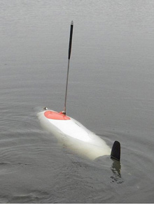
Using scientific echo sounders, stereo cameras, current profilers, and conductivity, temperature, and depth sensors, AUVs will improve the efficiency of fishery survey vessels and increase opportunities to survey in the oceanic boundary areas.
NOAA is involved in a range of fisheries scientific research and technology development activities, including biology, ecology, social sciences, oceanography, and engineering. These activities help us conserve and manage living marine resources today and will continue to do so well into the future:
“Autonomous underwater vehicles (AUVs) are programmable robotic submarine sensor platforms that can be deployed from ships, small craft, or from shore.
AUV technology is emerging and rapidly advancing; AUVs are getting smaller and less expensive while accommodating more sensors and allowing longer mission durations. All of these will improve the spatial and temporal coverage needed for ecosystem observations, thus allowing for more effective fisheries management actions.” (from: Electronics and Water Sometimes Do Mix: Advanced Technologies for Surveying Living Marine Resources)
Environmental Satellites
NOAA currently operates 16 environmental satellites and manages the processing and distribution of truly vast streams of data and images. These data and images are essentials for weather forecasts, climate research, forest fires detection, and much more.
The next generation of NOAA satellites will emerge over the next 20 years, evolving with technology and the needs of the nation:
“Geostationary Operational Environmental Satellite (GOES)-R will provide atmospheric, oceanic, climatic, solar, and space data unlike anything seen before in the history of Earth observations. This new satellite will scan the Earth nearly five times faster than the current GOES. The satellites will provide television meteorologists, private weather companies, the aviation and agriculture communities, and national and international government agencies with about one hundred times the amount of data currently provided.” (from: The Future of Environmental Satellites)
What’s Inside…
In responding to our call to paint a picture of where major NOAA activities might be 20 years down the road, NOAA staff delivered a range of visions.
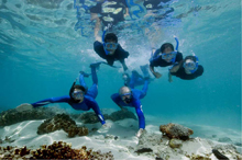
Moving into the future, the sanctuary program will continue to work with partners to explore how the world of film can increase public understanding of the value of our marine sanctuaries. Here, Jean-Michel Cousteau and the Underwater Treasures Team explore Fagatele Bay in American Samoa, as featured in a recent documentary. Photo courtesy of Richard C. Murphy, Ocean Futures Society.
What perhaps lies ahead? A Weather Service that delivers all types of environmental information; ships that are capable of conducting several different types of research; or a national system of marine protected areas that will enhance information sharing and management of these areas. Or perhaps when you peer into our crystal ball, you’ll see us making use of new and innovative technologies to inform the public of the value of marine sanctuaries or possibilities of legislative shifts that will strengthen our ability to manage fisheries and work with states to manage coastal areas.
We invite you to browse through on the stories to the right and see what’s in store for us over the next two decades…
Topic List
Below is a list of topics with Vision stories. Click on a topic to learn what the next 20 years holds for that topic within NOAA.
Atmospheric Research
Climate Research
Coastal Ecosystem Research
Coral Reef Conservation
Data Management
Environmental Satellites
Fisheries Management
Fisheries Science and Technology
Integrated Ocean Observations
Marine Protected Areas
Marine Sanctuaries
National Estuarine Research Reserve System
National Spatial Reference System
Nautical Charts
NOAA Aircraft
NOAA Corps
NOAA Ships
Ocean Research
Protected Resources
Remote Sensing
Spill Response
Surveying Using Satellites
Tides and Currents
Weather, Water, and Climate Forecasts and Warnings
