The National Spatial Reference System "Takes Flight": 1987 - 2007
The National Spatial Reference System (NSRS) includes a set of points on the Earth's surface whose locations have been accurately determined. These points serve as reference stations for many activities requiring accurate spatial information. Starting in the 1980s, the NSRS also includes a constellation of satellites that serve as "flying" reference stations. NOAA's National Geodetic Survey defines and manages this national coordinate system, which provides the foundation for transportation and communications; mapping and charting; and a multitude of scientific and engineering applications.
Without a good foundation, a building will collapse. Our transportation infrastructure is the same way. The location and placement of roads must be predetermined so that traffic runs smoothly. When building a bridge over water, construction teams have to make sure that the two sections of the bridge will meet at the same point. If they don't, the bridge will be unusable.
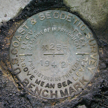
Survey marks, such as this one set in 1942 in Pike County, Pennsylvania, serve as permanent, accurate reference stations for precise positioning.
For 200 years, NOAA's National Geodetic Survey (NGS) and its partners have provided the foundation needed for these kinds of projects by setting approximately 850,000 permanent survey marks throughout the United States. Appropriate observations and calculations to determine accurate positional coordinates for these survey marks have also been made. These survey marks are the reference stations that, until recently, constituted the main component of the National Spatial Reference System (NSRS). Other NSRS components include a set of models and tools, such as models for how the Earth deforms and tools to help NSRS users process observations for determining positional coordinates.
Although NGS has been in the business of establishing reference stations for 200 years, it was the recent advent of the global positioning system (GPS), in the 1980s, that revolutionized the NSRS. GPS allowed surveyors and others to determine an exact location on the surface of the Earth with greater accuracy and speed than ever before.
That Was Then: 1987
In 1987, the NSRS contained approximately 250,000 reference stations whose horizontal coordinates were accurately known and approximately 500,000 reference stations whose vertical coordinates were accurately known. Only a few thousand reference stations existed for which both horizontal and vertical coordinates were accurately known.
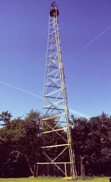
When survey marks were located on flat ground, large towers such as this were often built above them. Sometimes towers had to be built even on hill tops—to see over the trees on that same hill. The purpose of the tower was to provide a line-of-sight between survey marks.
To create the network of horizontal reference stations, surveyors marked each of the positions they had precisely located with a survey mark or monument. These marks were placed so that surveyors could see one marked position from another. To maximize the line-of-sight between survey marks, the marks were usually set on mountaintops or at high elevations.
When survey marks were set on flat land, large towers were often built above them to allow surveyors to see between marks. These towers allowed surveyors to observe angles and distances between marks over long distances. Using the collected data it is possible to calculate accurate horizontal coordinates for mark locations. Surveyors and others use these horizontal reference stations to determine horizontal coordinates for other points of interest by measuring appropriate angles and distances and performing appropriate calculations.
This is Now: 2007
In the 1980s, a revolution in surveying occurred: GPS technology made it possible to locate points with greater accuracy and speed and at lower cost than ever possible before.
GPS: The New "Flying" Reference Stations
GPS is a constellation of satellites that orbit approximately 11,000 miles above the Earth and broadcast radio wave signals. By determining the time that it takes for a radio wave signal to travel from a GPS satellite to a GPS receiver on the Earth, the distance between the satellite and receiver can be calculated and the receiver's exact location on the Earth can be determined. It sounds easy, but in fact, it is a very complicated process. For GPS to work, the receiver must be able to "see" or receive the signals from four or more of the satellites simultaneously. Also, positional coordinates for the satellites need to be precisely known at all times. Hence, the constellation of GPS satellites might be considered a network of "flying" reference stations.
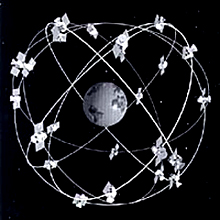
The global positioning system (GPS) is a constellation of satellites orbiting the Earth approximately 11,000 miles in space.
However, the need for "ground" reference stations has remained because GPS positioning entails some error, such as the effect of the atmosphere on the radio signals. A common solution to this problem is to apply "differential" GPS techniques by simultaneously deploying two or more GPS receivers with at least one located at a ground reference station whose coordinates are already known. If the two receivers are close enough together, then certain errors—such as those caused by the atmosphere—will be similar at both receivers. Hence, the size of the error can be estimated from the GPS data collected at the receiver with the known coordinates. This error estimate can be subtracted from the GPS data collected at the receiver whose coordinates are to be determined.
In 1987, Tennessee became the first state to establish a statewide network of ground reference stations positioned solely by differential GPS techniques. The accuracy of the coordinates determined using GPS far surpassed the accuracy of coordinates determined by classical "line-of-sight" measurements. In turn, each state has collaborated with NGS to establish their own statewide system of GPS-determined reference stations. The need for station-to-station line-of-sight measurements was effectively replaced by the need to see as much as the sky as possible.
CORS—Survey Marks of the Future
As advanced as GPS technology is, most commercially available GPS receivers are only accurate to within several yards. Considering that the Earth is almost 25,000 miles in circumference, the difference of a few yards may not seem important. This level of accuracy may be adequate for a hiker in the woods or someone driving a car, but there are many scientific, military, and engineering activities that require much higher levels of positioning accuracy—often to within a few inches or less.
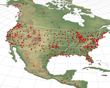
The Continuously Operating Reference Stations (CORS) system is a network that continually collects GPS signals and provides these data to GPS users via the Internet for precise positioning activities. Click image for larger view.
To provide measurements at this level of accuracy, in 1994, NGS married the concept of reference stations with GPS technology to develop the Continuously Operating Reference Station (CORS) network.
Each station in the CORS network is a stationary, permanent GPS receiver that collects satellite signals around the clock. NGS uses these data to determine precise three-dimensional positional coordinates for the CORS sites. Also, NGS makes these data publicly available via the Internet. With freely available GPS data from several hundreds of CORS sites, surveyors and others need only deploy one GPS receiver to do differential GPS positioning. The CORS network enables its users to position points with accuracies to within a fraction of an inch in all three dimensions. As of September 2006, NGS managed an international network containing more than 970 CORS, and this number is growing by about 15 sites per month. The CORS network now constitutes the foundation of the NSRS.
Height Modernization: GPS to the Rescue, Again
The traditional method for positioning vertical reference stations is called differential leveling. This method uses a known elevation at one location to determine the elevation at another location. It is a time-consuming process and not at all cost-effective. Every so often more money would have to be given, in large quantities, to fund another updating expedition. GPS reduces the need for lengthy expeditions such as these and is therefore very cost effective. As with horizontal positioning, the advanced technology of GPS will help replace the classical technique of vertical positioning.
Prior to the use of GPS for positioning, the NSRS was essentially two different systems—one for determining horizontal coordinates (latitude, longitude) and a separate system for determining height. One might say it was a "2 +1-dimensional" system. Now—thanks to GPS—the NSRS is a truly three-dimensional, unified system for determining latitude, longitude, and height.
Reliable elevation data is essential both for scientific inquiry and for safety and convenience. It allows people to measure, for example, how fast a piece of land is sinking (a process called subsidence). It improves aircraft navigational aids to make approach-and-landing procedures safer. Because it precisely pinpoints the rise and fall of land surfaces, it increases the efficiency of water delivery and drainage systems, and helps reduce urban and agricultural runoff and water pollution. For the same reason, it allows more precise modeling of storm-surge and pollution trajectories during extreme weather and hazardous spill events.
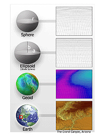
Because the surface of the Earth is so complex, geodesists use simplified, mathematical models of the Earth. The simplest model of the Earth is a sphere. A slightly more accurate model is an ellipsoid. A much more complex model of the Earth is the geoid, used to approximate mean sea level. Even the geoid is a simplified model, however, when compared to actual topographic relief, as shown in this image of four figures of the Earth.
One problem, however, is that heights determined by GPS differ from the heights needed for many applications. GPS provides a "geometric" height relative to the reference surface used for the NSRS. This reference surface is an ellipsoid, which is formed by rotating a two-dimensional ellipse around its shorter axis. The size and shape of the ellipsoid has been carefully chosen to closely approximate the Earth's surface, which is known to be flattened at the poles and to bulge outward at the equator because of the forces caused by Earth's rotation.
However, many people want to know elevations to determine which way water will flow, which depends on Earth's gravity field. If the Earth were truly a homogeneous chunk of matter in the shape of a solid ellipsoid, then GPS-determined heights would indeed reflect how water flows. The Earth, however, is neither homogeneous nor does its shape conform exactly to an ellipsoid. It is composed of materials with many different gravitational properties—for example rocks and water—and it has many mountains and valleys. Therefore, GPS alone cannot provide the heights people need for applications such as flood mitigation and irrigation.
However, obtaining geometric heights with GPS is much more economical than determining gravity-related heights. To address this problem, in 1990, NGS introduced a "geoid" model that represents the difference between GPS-determined geometric heights and gravity-related heights. NGS continues to improve the geoid model, using satellites and other airborne platforms to measure Earth's gravity field in even greater detail and incorporating these data into the geoid model.
Conclusion
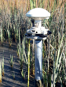
This CORS station is a continuously operating GPS receiver that determines accurate elevations quickly, inexpensively, and in places where traditional methods are impractical, such as this marsh.
In economic terms, a state-of-the-art National Spatial Reference System saves state and local governments and private industry vast sums of money. The NSRS replaces expensive, labor-intensive field surveying projects (including flood-plain and other mapping activities) with new, more timely and cost-efficient GPS technology. It reduces engineering errors and disasters caused by changing land surfaces due to subsidence, floods, earthquakes, and other natural phenomena.
As in recent years, the NSRS will continue to depend more and more on GPS. Using GPS, survey marks can be positioned without the need to see from one point to another. In addition, GPS has allowed the horizontal reference system to be effectively integrated with the vertical reference system. Most importantly, GPS has allowed positional coordinates to be determined more accurately, faster, and more economically than ever before. Truly, the NSRS has taken flight!
Contributed by Richard Snay, NOAA's National Ocean Service
