Environmental Satellites: Then and Now
NOAA's National Environmental Satellite, Data, and Information Service operates the country's environmental satellites and manages the processing, distribution, and archiving of this satellite data. Cloud images collected from these satellites are seen daily on television weather forecasts and data collected are also used for applications such as climate research and prediction, volcanic eruption monitoring, forest fire detection, and search and rescue operations.
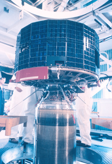
The TIROS-1 satellite mated to a rocket for launching. Click image for larger view.
NOAA's environmental satellite program began in 1960, with the launch of Television Infrared Observation Satellite (TIROS-1) and continues today as more advanced satellites are developed and launched. The most recent of these satellites are the polar-orbiting satellite NOAA-18, launched in May of 2005, and the geostationary satellite GOES-13, launched in June of 2006.
During the decades between TIROS-1 and NOAA-18 and GOES-13, NOAA has developed remarkable technological advancements in both polar-orbiting and geostationary satellites. Among other benefits, these improvements have increased warning times for severe weather events and disasters and allowed emergency workers to better asses the scope and severity of damage, thus helping them plan an effective response.
1960: One Lonely Satellite

Components of the TIROS-1 satellite system. Click image for larger view.
The TIROS spacecraft were the beginning of a long series of polar-orbiting meteorological satellites. The first TIROS satellite was launched in 1960 and by 1972, when TIROS research and development was completed, a total of 10 TIROS spacecraft launched would be launched.
TIROS led the way for the first operational weather satellite program (often referred to as ESSA-1) of the Environmental Sciences Service Administration (ESSA)—the predecessor of NOAA. These satellites were developed by the National Aeronautics and Space Administration (NASA) and managed by the ESSA, with a goal of establishing a global weather satellite program.
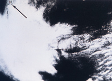
Among the most famous of early satellite weather photographs. Click image for larger view and full caption.
TIROS-1 produced our first systematic images of Earth from space. Its single television camera could point at the Earth (primarily North America) only for a limited period each time it orbited the Earth. This experimental satellite series eventually carried a variety of sensors, evolving as technology and experience increased.
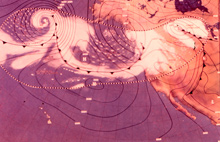
Surface weather map of Pacific frontal storm derived from TIROS-1 data. Click image for larger view.
Working together, NASA and ESSA improved the designs and capabilities of these satellites. TIROS-1 through TIROS-10 contained simple television cameras, while four of the 10 TIROS spacecraft also included infrared sensors.
2007: A Complete Satellite System
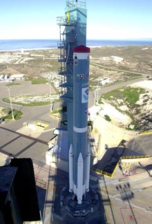
The polar-orbiting NOAA 18 (N) satellite on the launch pad. Click image for larger view.
Fast forward through over 40 years of innovation, imagination, and changing user needs, and you will reach an era of advanced imaging and sensing, providing a more complete view of the Earth than ever possible before. This comprehensive satellite system is made up of two types of satellites: polar-orbiting and geostationary.
Polar-orbiting Operational Environmental Satellites (POES)
Polar-orbiting satellites are able to provide long-term monitoring of the entire Earth, tracking atmospheric variables such as temperature and providing atmospheric data and cloud images. Following a nearly circular path around the Earth, polar-orbiting satellites track atmospheric conditions that eventually affect the weather and climate of the United States.
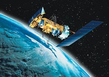
An artist's rendition of the NOAA 18 (N) satellite in orbit. Click image for larger view.
These satellites provide both visible and infrared images and monitor such atmospheric metrics as ozone levels. They send more than 16,000 global measurements daily via one of NOAA's Command and Data Acquisition stations to NOAA computers. These data add valuable information to forecasting models, especially for remote ocean areas where conventional data are lacking. Important information such as ozone levels and long-term weather forecasts are gleaned from data gathered by polar-orbiting satellites and relayed to the public.
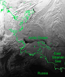
This image was colllected from the NOAA 18 AVHRR Instrument. Click image for larger view.
The newest polar-orbiter in the constellation is NOAA-18. This satellite is equipped with many advanced instruments, including the Advanced Microwave Sounding Units (AMSU -A1 and -A2), the High Resolution Infrared Radiation Sounder (HIRS), and the Advanced Very High Resolution Radiometer (AVHRR). These instruments take important measurements such as sea surface temperature, humidity, and other atmospheric measurements that characterize global weather. These instruments also provide visible and infrared images. These products are useful in many different forecasting and tracking tasks, including monitoring and predicting the path of severe storms and hurricanes.
Geostationary Operational Environmental Satellites (GOES)
Satellites in a geostationary orbit continuously point at one particular portion of the Earth’s surface. They follow the equatorial plane of the Earth at a speed matching the Earth's rotation, allowing them to “hover” continuously over one position on the surface. This “geosynchronous” plane is about 35,800 kilometers (22,300 miles) above the Earth, high enough to allow the satellites a full view of the Western Hemisphere.
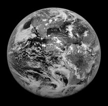
The first image from the GOES-13 spacecraft captured the Earth from space. Click image for larger view.
Because they stay above a fixed spot on the Earth’s surface, geostationary satellites constantly watch for the atmospheric triggers of severe weather conditions such as tornadoes, flash floods, hail storms, and hurricanes. When these conditions develop in the view of these satellites, they are able to monitor storm development and track its movements. These spacecraft are the kings of continuous monitoring necessary for intensive data analysis and weather forecasting. Being able to monitor these events closely enables decision makers to plan ahead for conditions that may directly affect public safety, property, and ultimately, economic health and development.
Geostationary Operational Environmental Satellites, or “GOES,” imagery is also used to monitor severe storms and squall lines that can lead to tornadoes, estimate rainfall during thunderstorms and hurricanes for flash flood warnings, and estimate snowfall accumulations and the overall extent of snow cover. Such data help NOAA meteorologists issue tornado, thunderstorm, flood, and winter storm warnings as well as spring snow melt advisories. Satellite sensors also detect ice fields and map the movements of sea and lake ice and monitor wind speed and direction at high altitudes in support of aviation activities.
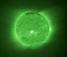
This image from the GOES-13 SXI instrument shows the sun's x-rays. Click image for larger view.
GOES-13 is the latest in the series of Earth monitoring satellites in geostationary orbit. The imager and sounder instruments on GOES-13 provide regular measurements of the Earth's atmosphere, cloud cover, ocean temperatures, and land surfaces. Of particular interest and utility is the GOES-13 Solar X-ray Imager (SXI), which monitors the sun's x-rays. This instrument is substantially more sensitive than the analog GOES-12 instrument, allowing for longer exposure times. The information from these images allows scientists to track and predict the effects of phenomena such as solar flares that can interfere with communications and navigation systems.
Conclusion
When comparing the beginnings of the satellite program in 1960 to the advanced system NOAA flies today, it is clear that our ability to increase the capabilities of our satellites is only limited by our imagination. Now that we are completing the latest generation of satellites, NOAA is planning and developing the next generation.
The future of the polar-orbiting satellite program lies in the creation of the National Polar-orbiting Operational Environmental Satellite System, or “NPOESS.” This cooperative effort between NOAA, the Department of Defense, and NASA seeks to combine the innovation efforts of all three agencies, to create one efficient program that will meet the needs of both military and civilian users.
The geostationary satellite program is also working on a new series of satellites called “GOES-R.” The technology of this group of spacecraft will result in more timely and accurate weather forecasts and will improve support for the detection and observation of weather phenomena that impacts our daily lives.
Contributed by Tara Mairs and Dave Irwin, NOAA’s National Environmental Satellite, Data and Information Service
Works Consulted
Hastings, D. A. (1992). Advanced Very High Resolution Radiometer (AVHRR): A Brief Reference Guide. Photogrammetric Engineering and Remote Sensing, volume 58, no. 8, August 1992, pp. 1183-1188.
Norton, J. (1991). NOAA Command and Data Acquisition Station. Retrieved September 26, 2006, from: http://www.wcda.noaa.gov/history1.htm.
NESDIS Office of Satellite Operations. (2006). Geostationary satellites. Retrieved September 26, 2006, from: http://www.oso.noaa.gov/goes/.
NESDIS Office of Systems Development. (2006). The GOES-N Spacecraft. Retrieved September 26, 2006, from: http://www.osd.noaa.gov/GOES/goes_n.htm.
GOES-R Program Office. (2005). GOES-R Program Office Web site. Retrieved September 26, 2006, from: https://osd.goes.noaa.gov/.
