The Norwegian North-Atlantic Expedition, 1876-1878 (three of seven bindings)
This multi-volume work relates the accomplishments of the Norwegian expedition throughout the Norwegian Sea from 1876 to 1878 on the ship Voringen. In many respects, this voyage represented the future direction of oceanography, even more so than the British Challenger expedition earlier in the decade.
 Bin. V, Title
page
View High-Resolution Image (TIF, 860 KB) Bin. V, Plate
5
View High-Resolution Image (TIF, 18.1 MB) Bin. V, Plate
6
View High-Resolution Image (TIF, 18.2 MB) Bin. V, Page
32
View High-Resolution Image (TIF, 1.2 MB) Bin. V, Page
33
View High-Resolution Image (TIF, 1.3 MB) Bin. V, Page
34
View High-Resolution Image (TIF, 1 MB) Bin. V, Page
35
View High-Resolution Image (TIF, 1.2 MB) Bin. V, Page
36
View High-Resolution Image (TIF, 1.2 MB)
This excerpt includes the title page, plates 5 and 6, and pages 32-36, all from Binding V of The Norwegian North-Atlantic Expedition, 1876-1878.
View the Flash version.
By the latter half of the 19th century, oceanography was truly international in scope. In contrast to Britains’s Challenger expedition, which conducted a world-wide inventory of the seas, the Voringen expedition was a detailed study of the physical characteristics of the Norwegian Sea between Norway, Iceland, Spitsbergen, and Greenland. The leaders of the expedition, Henrik Mohn and George Sars, convinced the Norwegian government to fund the expedition because no extensive investigations of the open seas adjacent to Norway had as yet been undertaken by the government. Mohn and Sars linked the science of oceanography to the well-being of Norway as a nation when Mohn wrote that the sea "is the origin and preserver of our existence as a civilized nation; and that expanse of sea being as regards its physical conditions well nigh unknown, on Norway should first devolve the labour of their solution." (b. I, Historical Account, p.6)

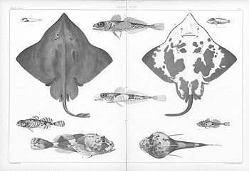
The expedition collected many deep-sea fishes, illustrating and describing them in great detail. The largest figures in this illustration are Arctic skates, collected in the open ocean west of the northern coast of Spitzbergen from a depth of 459 fathoms. (b. IV, Zoology, Fishes, pl. 1, figs. 1-10)
The expedition was also meant to enhance national prestige and match the British expeditions in scope, comprising:
"...the depth of the sea, its temperature, the chemical composition of its water, the currents prevailing there, both at the surface and in the depths, the nature and geological formation of the bottom, meteorological and magnetical phenomena, and more especially all forms of animal and vegetable life. The results of such an investigation might be expected to throw light upon the physical conditions determining our climate, and, above all, upon the biological characteristics of our migratory fishes." (b. I, Historical Account, p.6)
In addition to exploring the physical conditions of the Norwegian sea, the account is a travelogue of areas visited. Enjoy this description and beautiful imagery of Spitzbergen:
"On the 5th of August, 1878, we got our first view of Spitzbergen. About noon the "Voringen" bore down on South Spitzbergen, a cloud-capt land, with snow-fields and glaciers. Off South Cape are seen a number of small, low-lying islands…There, is seen a fragment resembling a swan, with its long extended neck, a form frequently assumed by the Polar drift-ice." (b. V, Contributions to the Geography and Natural History of the Northern Regions of Europe, pp. 32-33)
The account of the expedition was issued in seven bindings (volumes), in 28 parts, with text in both Norwegian and English. NOAA holds bindings I, IV, and V. For a map of the expeditionís tracks, see page 381 (pdf); for an image of the ship, see page 382 (pdf).
- Editors: Henrik Mohn (1835-1916) and G.O. Sars (1837-1927)
- Date Published: 1880
- Publisher: Grøndahl & Søns Bogtrykkeri
- Location:
Christiania, Norway
Length:
Binding I, Historical Account, 46 pages; The Apparatus and How Used, 54 pages
Binding IV, Chemistry, 76 pages; Zoology: Fishes, 164 pages; Zoology: Gephyrea, 58 pages;
Binding V, Astronomical Observations, 23 pages; Magnetic Observations, 30 pages; Geography and Natural History, 36 pages
View Complete Rare Book
The Norwegian North-Atlantic Expedition, 1876-1878 (pdf, 383 MB)
NOAA's Rare Book Collection includes bindings I, IV, and V.
Binding I begins on page 333 of the pdf
Binding IV begins on page 1 of the pdf
Binding V begins on page 440 of the pdf
