
NOAA: At the Forefront of the El Niño-Southern Oscillation
The ability to monitor and predict the El Niño-Southern Oscillation (ENSO) plays an essential role in NOAA's mission to assess and forecast the impacts of short- to long-term climate variability. ENSO, a major climate pattern in the tropical Pacific Ocean, is responsible for climate variations that have worldwide socio-economic consequences. NOAA scientists translate their understanding of ENSO into products that enable public and private users to prepare for and mitigate ENSO impacts.

During the winter months, El Niño episodes feature a strong jet stream and storm track across the southern part of the United States and less storminess and milder-than-average conditions across the North. Click image for larger view.
The broad expanse of the tropical Pacific Ocean is home to one of the most captivating large-scale climate patterns in the world: the El Niño-Southern Oscillation (ENSO). Strong coupling between ocean surface temperatures and the atmosphere gives rise to a cycle that oscillates between El Niño (warm) and La Niña (cold) episodes. During El Niño events, the easterly trade winds (winds along the equator that blow from east to west) weaken, allowing warm water in the western Pacific to migrate eastward. During La Niña events, however, the opposite occurs—tropical sea surface temperatures are cooler in the equatorial east Pacific and accompanied by stronger equatorial easterly trade winds.
Though seemingly innocuous, the irregular pulse of the Pacific ocean-atmosphere system has profound implications worldwide, ranging from an increased flood risk in some regions of the United States to drought conditions in others. Over the past several decades, NOAA's leadership in detecting, predicting, and understanding the impacts of ENSO have enhanced seasonal climate outlooks and have resulted in timely assessments used by various scientific communities and the general public.
Detection: Components of the ENSO Observing System
The 10-year (1985-94) Tropical Ocean Global Atmosphere (TOGA) program was an international effort designed to improve monitoring of the tropical oceans, particularly the Pacific Ocean, where regular and routine observations are essential to understanding and predicting ENSO. As a major partner in the TOGA program, NOAA helped design, and continues to maintain, the major components of the ENSO Observing System. These components include:
- moored buoys, or the Tropical Atmosphere-Ocean (TAO) array, which became the TAO/TRITON array in 2000;
- the Voluntary Observing Ship (VOS) program to measure ocean temperature profiles;
- a drifting buoy network to capture ocean currents and sea surface temperatures; and
- a tide gage network to monitor sea level changes.

This diagram shows the many components of the ENSO Observing System, stretched out along the Pacific Ocean. Click image for larger view.
Since the end of TOGA, Argo floats to measure upper-ocean temperature and salinity have been added to the observing system. These observing system elements in the ocean are complemented by a constellation of Earth-observing satellites measuring remotely from space.
The use of moored buoys in the equatorial Pacific dates back to the late 1970s, when NOAA first deployed surface moorings. This idea was expanded by NOAA scientist Stan Hayes, who suggested that moored buoys should span the tropical Pacific and transmit observations in real-time so ENSO could be reliably monitored. Spurred on by the unpredicted 1982-83 El Niño, NOAA began funding the TAO/TRITON array.
During December 1994, the final month of the TOGA program, the full array of nearly 70 moored ocean buoys was completed. The TAO/TRITON buoys monitor surface winds, relative humidity, air temperature, and ocean temperatures. Several buoys also have rain gauges, current meters, and salinity and radiation sensors.
The TAO/TRITON array, along with the other components of the ENSO Observing System, has improved data coverage in the equatorial Pacific. Observations are regularly transmitted to NOAA satellites several times a day, enhancing NOAA's capability to detect, predict, and understand ENSO.Prediction: Translating Observations into Predictive Skill
The data received from NOAA's state-of-the-art monitoring system underpins an assortment of computer models and statistical methods. Alongside established scientific acumen, these are the primary tools that forecasters use to predict the evolution of ENSO.
Data provided by the ENSO Observing System are fed into several computer models at NOAA's National Centers for Environmental Prediction (NCEP). NCEP's Climate Forecast System (CFS) is the first fully coupled computer model (i.e., ocean and atmosphere interact) that produces weekly to seasonal climate forecasts. In addition to the coupled computer models, NOAA scientists benefit from a suite of statistical methods, which improves their ability to predict ENSO. NOAA's Sea Surface Temperature Consolidated Forecast harnesses the skill provided by coupled and statistical models to forecast surface temperature anomalies in the ENSO region of the tropical Pacific Ocean where the global atmospheric circulation is particularly sensitive to underlying oceanic conditions.

This
animation shows weekly averaged sea surface temperatures
(in °C)
for the twelve-week period between December 20, 2006 and
March 7, 2007.
Aided by these predictive tools, NOAA produces several forecast discussions that describe the current and future status of ENSO. The ENSO discussions began in the mid-1980s at the NOAA Climate Prediction Center (CPC). The Weekly ENSO Update compliments the ENSO Diagnostic Discussion that is updated every month; the update is also printed in the Forecast Forum section of NOAA CPC's Climate Diagnostics Bulletin. These Web products and publications provide timely, accurate information on the status of ENSO to the scientific community, the public, and policy makers.
Understanding: Integrated Products for the User
NOAA understands that ENSO is linked to numerous climate and weather impacts in the United States, which can be both disastrous and beneficial to society. A suite of NOAA products, based on the observations and models described above, enables users to make timely and cost-efficient decisions when an ENSO event is predicted.

NOAA products, such as this map for the lower 48 states that illustrates the likelihood of extremes of temperature and precipitation during El Niño events, can be used to help decision makers plan when ENSO events are predicted. Click image for larger view.
ENSO contributes to droughts, wildfires, floods, and hurricanes; conversely, it can also provide benefits such as warmer-than-average winters that lower heating costs. To meet the needs of a diverse user community (e.g., agribusiness, power utilities, water resources management, insurance), NOAA experts produce several weekly-to-seasonal assessments. Monthly-to-Seasonal Climate Outlooks and the U.S. Seasonal Drought Outlook provide long-range predictive information on temperature and precipitation anomalies in the United States. Products like the U.S. Hazards Assessment and the U.S. Drought Monitor provide users with decision-making information on medium to extended timescales (3-14 days). Special Climate Assessments are issued for events of interest, such as significant El Niño or La Niña episodes.

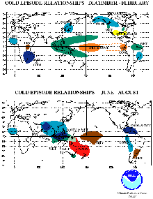
El Niño impacts on weather in Northern Hemisphere winter and summer. Click image for larger view.
La Niña impacts on weather in Northern Hemisphere winter and summer. Click image for larger view.
NOAA plays an important role by translating its understanding of ENSO into integrated products that benefit the user community.
Looking to the Future
Over the next several decades, NOAA will build upon its status as a leader in the detection, prediction, and understanding of ENSO. NOAA's role in developing and maintaining the Integrated Ocean Observing System, which is a part of the international Global Earth Observation System of Systems, will help to improve ENSO forecasts by providing enhanced global data sets for improved understanding of ENSO and for ENSO forecast model development and initialization.
Advancements in predictive systems, such as NOAA's Climate Forecast System, will enable NOAA forecasters to provide timely, reliable climate outlooks that will aid the user community. Global hazard and benefit assessments will provide an integrated and comprehensive examination of ENSO evolution and impacts.
Contributed by Michelle L'Heureux, NOAA's National Weather Service
Works Consulted
Changnon, S.A. (2000). El Niño 1997-1998: The Climate Event of the Century. New York, New York: Oxford University Press.
McPhaden, M.J. (2004). Evolution of the 2002/03 El Niño. Bulletin of the American Meteorological Society, 85(5), 677-695.
NOAA Pacific Marine Environmental Laboratory (PMEL). (2006). Tropical Atmosphere Ocean Project. Retrieved July 25, 2006, from http://www.pmel.noaa.gov/tao/.
NOAA Climate Prediction Center (CPC). (2006). CPC Web site. Retrieved July 25, 2006, from http://www.cpc.ncep.noaa.gov/.