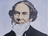
Ernest Lester Jones: Athlete, Idealist, Leader of the U.S. Coast and Geodetic Survey, and Father of the NOAA Corps
- A Federal Career Via Baseball
- Early Years in New Jersey and Virginia
- Unleashing a Firestorm
- Leading the Survey
- Expanding the Survey
- A Life Lost Too Soon
A Federal Career Via Baseball and Princeton

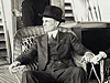
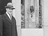
E. Lester Jones and his wife in 1928 aboard the Lydonia, a U.S. Navy vessel during World War I that the Coast and Geodetic Survey acquired in 1919. Click image for larger view.
As a young man, Ernest Lester Jones (E. Lester Jones as he preferred) was a very good baseball player. He also happened to attend Princeton University. Although he did not know it at the time, his ability on the diamond and choice of schools would control his destiny for the final sixteen years of his life. For it so happened that the future 28th President of the United States, Woodrow Wilson, was both a professor at Princeton and president of the Princeton University Baseball Association while Jones studied there in the mid-1890s.
At Princeton’s 100th anniversary in 1896, Wilson delivered a famous speech, “Princeton in the Nation’s Service,” in which he argued that universities were responsible "to illuminate duty by every lesson that can be drawn out of the past.” Following his inauguration to the presidency in 1913, Wilson acted on this belief. He appointed a number of outstanding university-educated men to positions in the federal government, including E. Lester Jones, thereby launching Jones into a career of public service.
Early Years in New Jersey and Virginia
Very little in Jones’s early life hinted that he was destined to become one of the most effective federal bureaucrats of the early 20th century and the greatest leader of the Coast and Geodetic Survey since Alexander Dallas Bache. He was born in East Orange, New Jersey, in 1876, the son of a prominent and prosperous publisher. After Princeton, Jones studied in Heidelberg, Germany, specializing in forestry and zoology.
Upon his return to the United States, Jones worked in the family publishing business but still found time for baseball. He played on amateur teams in New Jersey and Virginia and managed and captained a team for two seasons in 1904 and 1905 that defeated the Brooklyn Dodgers 4-2 in an exhibition game, but was crushed by the New York Giants. Concurrently, he continued his studies with special interest in animal husbandry and established a 300-acre farm in Culpeper County, Virginia, that specialized in draft horses, shorthorn cattle, and dairy cattle.
Unleashing a Firestorm Early in His Career
Jones became the deputy commissioner of the U.S. Commission of Fish and Fisheries in 1913. He soon traveled to Alaska to investigate the status of the salmon fisheries, exploitation of commercial fur-bearing animals, treatment of native Americans who depended on Alaska’s resources, and the activities of responsible government officials. His “Report of Alaska Investigation” and subsequent Congressional testimony unleashed a firestorm of outrage from many powerful interests including big business, elements of academia that sided with the large cannery interests, and unprincipled government officials. In short, he hit the nail on the head and many of the recommendations made in his report were later enacted.Leading the Coast and Geodetic Survey as an “Engineer of Men”

Launching of the Coast and Geodetic Survey ship E. Lester Jones in 1940. Named in memory of the Survey’s 11th superintendent and Father of the NOAA Corps, the ship sailed for 27 years, much of the time in Alaskan waters. Click image for larger view.
During Jones' time in Alaska he became knowledgeable of the many difficulties in charting its waterways and the issues surrounding its international boundary with Canada. Because of his familiarity with Alaska and his reputation for integrity, Jones was a natural choice to head the Coast and Geodetic Survey (the Survey). William Redfield, the Secretary of Commerce, appointed Jones as the eleventh superintendent to head the Survey in 1915.
Although his academic background and work with the Fish Commission were in biological sciences, Jones quickly grasped the intricacies of the Survey and began attacking problems that affected its efficiency. In his own words, he was an “engineer of men” and knew how to get the best out of his personnel. But Jones also demonstrated that he had a broader view by the opening paragraph of his first annual Coast and Geodetic Survey report: “Part 1 explains the needs of the Bureau by text and illustrations, and is an appeal for greater recognition of its essential requirements. With the increased work in recent years there has been no corresponding increase in the force and equipment, which is a pertinent cause for the backwardness of much of the work. ” He was blunt and direct—and right.
Following Wilson’s exhortation “to illuminate duty by every lesson that can be drawn out of the past,” Jones studied the history of the Survey, and, in particular, its experiences during the Civil War. With World War I looming, he helped to create the commissioned service of the Survey to better transfer its expertise to the armed services. The Survey’s commissioned service became the modern NOAA Corps.
No desk-bound patriot, Jones led by example. When called, he entered the Army and served during World War I in aeronautics as part of a pioneering group involved in aerial photography. For this he received numerous decorations. Unfortunately, Jones was severely gassed in the waning days of the war, and it affected him for the rest of his life.
Expanding the Survey Following World War I

Pioneer Post 1 presented this plaque to the Coast and Geodetic Survey in 1940 for installation on the U.S. Coast and Geodetic Survey ship E. Lester Jones to commemorate Jones’ founding of the American Legion. Click image for larger view.
After World War I, Jones expanded Survey work in all aspects of geophysics including studies of the ionosphere 1 and aurora 2, the deep sea, and seismology 3. Geodesy made notable advances during his tenure with the North American Datum of 1927 4, adopting mean sea level as a national vertical datum for mapping and engineering, and participation in the World Longitude Campaign, an international program of multi-year longitude observations to prove or disprove the theory of continental drift.
Because of his wartime experiences, Jones was a tireless advocate of aerial photography for mapping and was a major proponent for rapidly expanding this technology. Under his guidance and because it excelled in nautical charting, the Survey acquired responsibility for all civil aeronautical charting under the Air Commerce Act of 1926. He ensured that the Survey became the chief federal agency for seismology research and developed the first earthquake engineering test laboratory.
He helped to develop radio acoustic ranging and the first precision positioning system entirely uncoupled from visual observation and helped to discover the deep sound channel of the ocean. He purchased the first offset lithography presses for the Survey, greatly improving the efficiency of chart production.
Through all this, Jones relentlessly pursued higher salaries and better working conditions for civil service employees and, in particular, for more professional treatment of Survey workers. Besides his work in the Survey during this period, he also founded the American Legion, served as first commander of its Pioneer Post No. 1 in Washington, D.C., and fought for the rights of veterans following his return from the war.
A Life Lost Too Soon
Because of his reputation for integrity, four U.S. presidents entrusted the Coast and Geodetic Survey to his leadership. The Survey that Jones entered in 1915 was a pale shadow of the one he left prematurely in 1929 at age 53, succumbing to the long-term effects of the poison gas he encountered in World War I. E. Lester Jones left behind a revitalized Coast and Geodetic Survey that was at the forefront of many of the geophysical and oceanographic sciences of the day. His early death was an enormous loss for American science, the Survey, and the nation.
1. The ionosphere is a region of the earth's atmosphere extending from about 80 to 400 km (50 to 250 mi) above the surface of the earth.
2. The aurora is an atmospheric phenomenon appearing as streamers or bands of light sometimes visible in the night sky in northern or southern regions of the earth and thought to be caused by charged particles from the sun entering the earth's magnetic field and stimulating molecules in the atmosphere.
3. Seismology is the study of earthquakes.
4. The North American Datum has horizontal and vertical components. The horizontal datum is a collection of specific points on the earth that have been identified according to their precise northerly or southerly location (latitude) and easterly or westerly location (longitude). The vertical datum is a collection of specific points on the earth with known heights either above or below mean sea level.