World War II: Transforming the Technological, Geographic and Social Landscapes of NOAA Legacy Organizations
- Adapting and Mobilizing for War
- Turning to Women
- Civilian to Military
- Legendary Ship Pathfinder
- Applying the Skills
- New Battlefield Technologies
- War's End
- In Memoriam
Adapting and Mobilizing for War

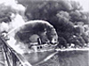
The Coast and Geodetic Survey and the Weather Bureau answered the call to arms during World War II. Over 1,100 Coast and Geodetic Survey personnel and 700 members of the Weather Service voluntarily joined the fighting forces. Click image for larger view.
World War II, more than any event since the founding of the Survey of the Coast 1 in 1807 and the Weather Bureau in 1871, dramatically transformed the technological, geographic, and social landscape of these two legacy agencies of today’s NOAA. These two organizations demonstrated extraordinary ability to adapt to wartime conditions. They embraced new and different technology, ventured to far and unfamiliar corners of the globe, welcomed women as vital and highly capable members of the workforce, and suddenly redirected their missions from civilian service to military support.
Although the United States did not officially enter the war until after the Japanese attack on Pearl Harbor in 1941, the real mobilization of the legacy agencies began in late 1939. The Coast and Geodetic Survey took part in such activities as the Army Corps of Engineers’ War Mapping Project, Army war games in Louisiana, and hydrographic surveys of strategic bases; the Weather Bureau prepared by taking part in the Defense Meteorological Committee beginning in July 1940 to build capabilities to monitor and forecast weather for worldwide military operations.
Turning to Women
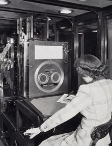
With more than half of its men in the joining the armed services during World War II, the Coast and Geodetic Survey hired women professionals to perform critical functions such as operating the tide prediction machine shown here. Click image for larger view.
As both groups mobilized, they expanded and replaced personnel to gear up for the war effort, turning to women to compensate for over 1,800 men who volunteered to serve in the military. Hiring women was part of a larger, nationwide movement that had far-ranging social consequences, even though postwar reduction in their workforce numbers blunted the full extent of the changes that were to come. It would take additional decades and the social upheaval of the civil rights and women's movements to cement women’s rightful roles in national policy and consciousness. But the roots of these changes were the vast increases in women personnel during the war and their great success in accomplishing the tasks before them. They helped transform the workplace of these two legacy agencies during this historic period.
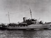
A Civilian to Military Metamorphosis

The Coast and Geodetic Survey mobilized its ship Lydonia for service during World War II. Click image for larger view.
With full mobilization for the war, both legacy agencies metaphormosed into military support departments. In the case of the Coast and Geodetic Survey, the laws and regulations enacted under E. Lester Jones, director from 1915 to 1929, governed the transfer of selected ships and officers (but not civilian employees) into the armed services. In the case of the Weather Bureau, much of the professionally trained personnel entered directly into military service.
The remaining civilians in the legacy agencies turned to producing scientific materials for the military. The Coast and Geodetic Survey made and printed more maps and charts for the war effort than it had printed in its entire history. Leaders like Paul A. Smith, head of the Aeronautical Charting Division, and H. Arnold Karo, the first commander of the new Army Aeronautical Chart Plant at St. Louis, were instrumental in developing new map production techniques which were adapted to printing tens of millions of nautical charts, aeronautical charts and other maps. Smith designed the world aeronautical charting system and supervised the production of over 2,500 separate bomb target charts including for such areas as Ploesti Oil Field, Hiroshima, and Nagasaki.
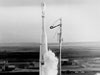
The Legendary Survey Ship Pathfinder

USS Pathfinder shortly after launching in 1942. The ship endured 50 bombing raids during its World War II service in the Pacific from 1942 to 1945. It produced thousands of maps and charts to support the war effort. Click image for larger view.
These tens of millions of maps stand “illuminated from the side,” by the 64,000 copies of maps and charts surveyed, produced, and printed aboard the legendary Coast and Geodetic Survey ship Pathfinder, deployed into navy service in the Pacific theatre. Its voyages illustrate the geographic expansion of legacy agency activities during the war–from the poles to the tropics and throughout the eastern and western hemispheres. These areas, once visited or occupied by agency personnel, were never abandoned, even in the postwar era. Remote Pacific islands became nuclear test sites monitored by the Weather Bureau and surveyed by the Coast and Geodetic Survey. Both organizations operated in areas associated with Cold War activities, particularly in the Arctic regions of North America.
Applying the Skills of the Coast and Geodetic Survey

One of the 64,000 copies of maps and charts produced on the Pathfinder. This chart shows Efate Island, which is about 1,100 miles east of Australia. July 1943. Click image for larger view.
The geodetic (surveying, mapping, and positioning) capabilities of the Coast and Geodetic Survey (the Survey) were an intrinsic part of both army and marine artillery operations. Survey officers served as the technical backbone of field artillery observation battalions, operating in the front lines and often in advance of the front throughout the European and Pacific theaters. The Survey put its geomagnetism and seismology capabilities to new uses such as degaussing (demagnetizing) ship hulls, constructing various types of magnetic devices, and providing information on air and ground vibrations for Trinity, the first atomic bomb test. The legacy agencies also applied these capabilities during the Cold War. For detecting underground nuclear tests, the Survey constructed and operated the World Wide Seismological Network. The Weather Bureau developed means to track radioactive material in the atmosphere leading to today’s Air Resources Laboratory.
New Battlefield Technologies
The war spawned new technologies for battle that entirely transformed the postwar activities of the legacy agencies. Radar became a tool for forecasting weather and tracking high-altitude radiosondes2, giving meteorologists in the Weather Bureau the ability to "see," sample, and understand the atmosphere. The Coast and Geodetic Survey revolutionized its capabilites for geodetic positioning and accurate distance measuring by adapting electronic positioning systems developed for bombing missions over Europe, into SHORAN, a short-range electronic navigation system, for hydrographic surveying. Postwar development of electronic distance measuring capabilities in systems like the Geodimeter brought an end to measuring baselines manually and changed the nature of geodetic surveying.
War’s End

Hydrographic survey signal on Mt. Suribachi, Iwo Jima. February 1945. Click image for larger view.
When the war ended, many Coast and Geodetic Survey and Weather Bureau personnel in military service returned to their civilian agencies, displacing some of the women who had served during the war. Twenty-five individuals who perished in the war were not so fortunate. However, for the survivors, the world and NOAA’s two legacy agencies had changed. A nucleus of women professionals stayed on, leading the way to a new era in which women and minorities are an intrinsic part of the NOAA of today. World War II changed not only the technical and geographic landscapes of the legacy agencies, but also their social fabric more than any other single event in their histories.
In Memoriam
Those members of the Coast and Geodetic Survey and Weather Bureau who made the supreme sacrifice during World War II:
| Coast and Geodetic Survey | Weather Bureau |
| Henry F. Bain | Luther H. Brady |
| Robert E. Barger | Lester S. Fodor |
| William Bolsaver | George F. Kubach |
| Levin R. Brown | Edward Weber |
| Ray B. Elliott | Wesley J. Morris |
| Calvin Farney | Douglas M. Patrick |
| Philip A. McAdam | William E. Stodhgill |
| Lawrence Mater | John V. Klobofski |
| Ormand E. May | Earnest A. Cole, Jr. |
| Charles H. Rodgers, Jr. | Charles Foster Jones |
| John Ronsheim | De Armas L. Smith |
| George D. Cowie | |
| Joseph Stirni | |
| Joseph A. Sosbee |
1: Long before the war, the Survey of the Coast's name changed to the Coast and Geodetic Survey (C&GS).
2: Radiosondes are instruments carried aloft by balloons to send back information on atmospheric temperature, pressure, and humidity via small radio transmitters.