Polar-orbiting and Geostationary Satellites: Revolutionizing Earth Observations
- NOAA Stands Sentinel
- Polar-orbiting Environmental Satellites
- Geostationary Operational Environmental Satellites
- Conclusion
NOAA Stands Sentinel

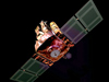
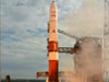
May 2006 launch of GOES-13 aboard a Boeing Delta IV rocket at Cape Canaveral Air Force Station in Florida. This satellite keeps vigil for atmospheric "triggers" of severe weather and carries a solar x-ray imager. Click image for larger view and image credit.
From the launch in 1960 of TIROS-I, the first weather satellite, to the latest geostationary operational environmental satellite launched in 2006, satellites have revolutionized NOAA’s ability to observe the earth, the atmosphere, the oceans, and space. Over that time, rockets built by the National Aeronautics and Space Administration and Department of Defense have launched nearly 50 NOAA satellites, providing the platforms for ever-improving sensing instruments that enable NOAA to stand sentinel over our nation and our planet.
Satellites transformed physical and certain biological science observations by enabling humans to view the Earth from high above, giving us a better vantage point to see and understand environmental patterns and phenomena. Thanks to satellites, NOAA monitors from space such diverse phenomena as hurricanes, winds, ozone, and precipitation in the atmosphere; floods, ice, volcanic ash, and wildfire on land; sea surface temperature, surface currents, and chlorophyll in the ocean; and solar x-rays and energetic particles in space. Before satellites, none of this was possible at the scale, efficiency, and accuracy that satellites provide.
Polar-orbiting Environmental Satellites

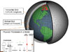
An artist's rendition of a NOAA polar-orbiting satellite. These satellites circle the earth in a north-south orbit, passing close to both poles. Click image for larger view and image credit.
Two types make up NOAA's system of satellites: polar-orbiting environmental satellites and geostationary environmental satellites. Polar-orbiting satellites enable long-term monitoring of the entire Earth, tracking atmospheric variables such as temperature and providing atmospheric data and cloud images. Following a nearly circular path around the Earth, polar-orbiting satellites track atmospheric conditions that eventually affect the weather and climate of the United States. These satellites provide both visible and infrared images and monitor atmospheric components such as ozone. They transmit more than 16,000 global measurements daily by way of NOAA command and data acquisition stations to NOAA computers. These data add valuable information to forecasting models, especially for remote ocean areas that lack data gathered by conventional means.

Polar-orbiting environmental satellite image of the central U.S. showing large prairie fires (small red blotches) and a large dust storm fanned by high winds. Click image for larger view.
The newest polar orbiter is NOAA-18 launched in May 2005. This satellite is equipped with many advanced instruments, including the advanced microwave sounding units, the high-resolution infrared radiation sounder1 and the advanced very high-resolution radiometer2. These instruments take important measurements such as sea surface temperature, humidity, and other atmospheric measurements that characterize global weather. NOAA-18 instruments also provide visible and infrared images. These are useful in forecasting and tracking, including monitoring and predicting the path of severe storms and hurricanes.
Geostationary Operational Environmental Satellites

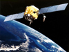
The U.S. normally operates two meteorological satellites in geostationary orbit over the equator. Each satellite views almost a third of the Earth's surface-one monitors North and South America and most of the Atlantic Ocean, the other North America and the Pacific Ocean. Click image for larger view.
Satellites in a geostationary orbit continuously point at one area of the Earth’s surface. They follow the Earth’s equator at a speed matching the Earth's rotation, allowing them to “hover” continuously over one position on the surface. This “geosynchronous” plane is about 35,800 km (22,300 miles) above the Earth, high enough to allow the satellites a full view of the Western Hemisphere.
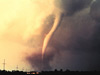
Because they stay above a fixed spot on the Earth’s surface, geostationary satellites constantly watch for the atmospheric triggers of severe weather conditions such as tornadoes, flash floods, hail storms, and hurricanes. When these conditions develop in the view of these satellites, they are able to monitor developing storms and track their movements.

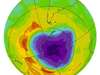
Color-enhanced and and standard geostationary operational environmental satellite images of atmospheric water vapor. Color-enhanced imagery aids meteorologists to easily and quickly see features of special interest. Click image for larger view.
Geostationary satellites can also estimate rainfall during thunderstorms and hurricanes for flash flood warnings as well as snowfall accumulations and the overall extent of snow cover. Such data help meteorologists issue tornado, thunderstorm, flood, and winter storm warnings as well as spring snow melt advisories. Satellite sensors also detect ice fields and map the movements of sea and lake ice and monitor wind speed and direction at high altitudes to support aviation activities. These spacecraft are the “kings of continuous monitoring” necessary for intensive data analysis and weather forecasting. Their ability to monitor these events closely enables decision makers to plan ahead for conditions that may directly affect public safety, property, and ultimately, economic health and development.
Conclusion
Without satellites, NOAA would continue to rely on the labor-intensive efforts of large numbers of people on the ground, at sea, and in the air to measure and observe earth, atmospheric, and oceanic phenomenon. Weather patterns would likely remain undetected in time for meaningful public safety warnings or they would remain little understood. The ability to monitor the Earth from satellites in space stands as one of the major breakthroughs in NOAA's storied 200-year history.
1. A sounder is an instrument that provides data to determine the vertical temperature and moisture profile of the atmosphere, surface and cloud top temperatures, and ozone distribution.
2. A radiometer is a radiation-detecting imager used for remotely determining cloud cover and the surface temperature. The term “surface” can mean the surface of the Earth, the upper surfaces of clouds, or the surface of a body of water.