The Breakthroughs
 was a major breakthrough in hydrographic surveying")
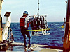
Multibeam sonar (illustrated below the ship) was a major breakthrough in hydrographic surveying. Data acquired with multibeam sonar have revolutionized human understanding of the seafloor and the efficiency of NOAA's Office of Coast Survey offshore surveying.
"The [ECOPATH] model’s simplicity and its ability to accurately identify ecological relationships have revolutionized scientists’ ability worldwide to understand complex marine ecosystems."
"In the late 1960s, NOAA’s Geophysical Fluid Dynamics Laboratory ...developed the first-of-its-kind general circulation climate model that combined both oceanic and atmospheric processes. Scientists were now able to understand how the ocean and atmosphere interacted with each other to influence climate."
"While ecologists have long studied and taught the concept of ecosystems, the concept of large marine ecosystems is a breakthrough in understanding how best to manage large ocean areas for sustained biological productivity."
Excerpts from three of NOAA’s 200th
Anniversary Top Ten Breakthroughs
“AHA!”
“Oh, I see!”
“Now I get it!”
Nearly all us have exclaimed these words in fits of breakthrough thinking, discoveries, and insight. Overcoming frustrating mental and physical barriers is relieving and often exciting. We sometimes wonder what took so long for “the light bulb to go on.”
Breakthroughs are exciting at NOAA, too; some have been remarkable, even awe-inspiring! We in the NOAA family, the American public, and world citizens have witnessed and benefited from scores of discoveries, innovations, and revolutionary changes over the course of 200 years. There was the time in 1949 when the Weather Bureau learned how to use backward air current trajectories to locate atomic test sites in the former Soviet Union at the onset of the Cold War. There was the period in the early 1920s when the Coast and Geodetic Survey began using aerial photography for the first time to create nautical charts, changing forever the technology of nautical charting. There was the period in the early 1950s when the Bureau of Commercial Fisheries discovered the Pacific Equatorial Undercurrent (also known as the Cromwell Current), a fundamental piece of information for understanding the ecosystem dynamics in the Pacific Ocean. There was also Doppler radar to warn of severe weather, electronic nautical charts, and geostationary earth observation satellites. The list goes on and on.

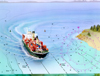
Breakthrough survey techniques for using the Global Positioning System developed by NOAA's National Geodetic Survey have had far-reaching impacts. Receivers such as those shown here allow surveyors to establish positions and to complete their work with greater accuracy and in a fraction of the time required by traditional survey methods.
The human spirit’s indomitable quest to “find a better way” has fertile ground in NOAA’s global “beat” of earth, ocean, space, and atmospheric science. We could also use the old bromide that, “Necessity is the mother of invention,” to explain the impetus behind some breakthroughs: those stimulated by war such as turning to radar to observe weather; ones incited by threats to human health like discovering the cause of ozone depletion in the stratosphere; or others brought on by new laws like creating bycatch reduction devices. These were developed to protect threatened and endangered sea turtles from incidental catch in commercial fisheries after Congress passed the Endangered Species Act in 1973. Whether it is forecasting harmful algal blooms, numerical weather forecasting, or creating civilian uses of the Global Positioning System, many breakthroughs have profoundly changed NOAA. You can read about many of these revolutionary transformations elsewhere on this Web site.

Images of the Sun’s corona from the LASCO imager aboard NASA’s Solar and Helispheric Observatory spacecraft. This space-based instrument dramatically improved NOAA forecasters’ ability to predict how space weather will affect the Earth.
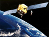
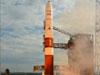
But what are NOAA’s ten most noteworthy and transforming breakthroughs over the last 200 years? With the exceptions of some of the early hydrographic survey breakthroughs, all of NOAA's Top Ten Breakthroughs have come since 1960 when NOAA and NASA launched TIROS I, the nation’s first weather satellite. Most are technological in nature or rely heavily on technology. And the needs they serve or the environments where they work are distributed evenly between the ocean, the atmosphere, the earth, and space. A number serve more than one of these vast realms, reinforcing the interconnectedness of earth, ocean, and atmosphere.
Half of NOAA's Top Ten Breakthroughs involve satellites as we continue to seek ways to understand Earth system dynamics. Some are creative applications of technology developed by other organizations for other purposes like revolutionizing land surveying with the military’s Global Position System and developing ways to analyze images from NASA’s satellite-based coronagraph for improved space environment forecasting. Three breakthroughs get double recognition by sharing honors with NOAA's Top Ten History Makers: Discovering the Cause of the Antarctic Ozone Hole, Susan Solomon; the Climate Model, Joseph Smagorinsky; and Polar-orbiting and Geostationary Satellites, David Simonds Johnson.
Now let’s look at (in alphabetical order), enjoy, and marvel at some of NOAA’s most momentous breakthrough achievements:
- Climate Model (late 1960s): Enabled scientists to understand for the first time how the ocean and atmosphere interacted with each other to influence climate.
- Coronagraph in Space (1995): Enabled improved forecasting of threats to electronic communications on Earth from coronal mass ejections on the Sun.
- ECOPATH Modeling (1983): Revolutionized scientists’ ability to accurately identify ecological relationships to understand complex marine ecosystems.
- Global Positioning System (1990s): Allowed NOAA’s National Geodetic Survey to develop revolutionary methods of positioning and surveying.
- Hydrographic Surveying Methods (throughout the 20th century): Enabled NOAA’s Office of Coast Survey to improve surveying efficiency in coastal waters by several different methods, most recently multibeam sonar starting in the 1970s.
- Large Marine Ecosystems (mid-1980s): Advanced the concept of understanding how best to manage large ocean areas for sustained biological productivity.
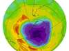
- Ozone Hole (late 1980s): Theorized and confirmed that man-made chlorine and bromine compounds were causing stratospheric ozone depletion.
- Polar-orbiting and Geostationary Satellites (1960 to present): Revolutionized NOAA’s ability to observe the earth, the atmosphere, the oceans, and space and to forecast natural phenomena.
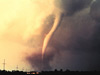
- Tornado Detection and Warnings (1970s): Discovered that using Doppler radar to peer into storms allows meteorologists to more confidently forecast tornados.
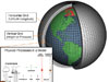
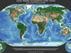
- Warming of the World Ocean (2000-2001): Documented for the first time an increase in heat content of the world ocean for the 40-year period between 1955 and 1998.
And now for our honorable mentions...