NOAA 200th Postcards from the Field April 2007
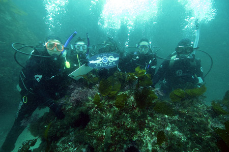 Channel Islands National Marine Sanctuary dive team members are shown conducting a REEF fish survey in
the cold dark waters off East Anacapa Island near the coast of California. REEF, which refers to the Reef Environmental Education Foundation, engages divers in the
conservation of marine habitats, primarily through the Fish Survey Project developed with guidance from NOAA's Southwest Fisheries Science Center. Dive team members
shown (from left): Chris Mobley, Laura Francis, John Brooks, Danielle Lipski, Rocio Lozano-Knowlton, and (behind the camera) Robert Schwemmer. In 1854, the U.S. Coast
Survey completed a chart of East Anacapa Island that included a sketch by William B. McMurtrie. The final copper plate etching was completed by James McNeill Whistler
who, in his unconventional style, added two flocks of birds in flight. During his short employment with the Coast Survey, Whistler was described as being "outrageous,
unconventional, original, monumentally egotistical, and highly talented."
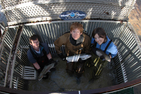 For more than six years, the Southwest Fisheries
Science Center has been studying endangered coho salmon and steelhead in coastal California's Santa Cruz Mountains. With an emphasis on ecology, population dynamics,
and genetics, tagged fish are providing insight on local adaptation and biology. Juvenile growth, diet, and movements are monitored in the upper watershed and estuary
along with the ocean survival of fish reared in each habitat. Since fish tags surfaced recently in a nearby gull colony, efforts are underway to assess local bird
predation levels on fish. Sean Hayes (left) holds a female about to head out to sea with an archival tag. Andy Jones and Sarah Rick hold adults about to be released
upstream to begin their spawning run.
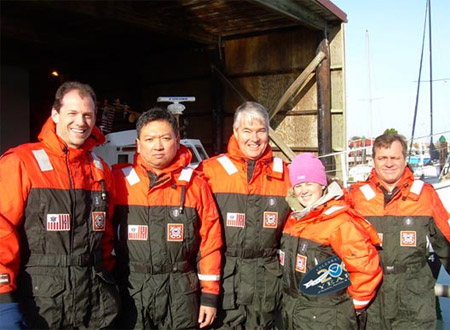 To gain a better understanding of customer needs, National Weather Service
forecasters from the Medford, Oregon Weather Forecast Office, hosted by the U.S. Coast Guard Lifeboat Station Coos Bay, recently experienced waves and hazardous bar
crossing conditions, bobbing for about an hour between jetties and the near shore. By that time, they had new insight into producing better marine forecasts – and
their complexions were infused with shades of green. Shown (from left): Ryan Sandler, Frederic Bunnag, Mike W. Johnson, Katie Burtis, and Sven Nelaimischkies.
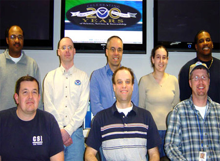 The National Weather Service's Mount Holly office (New
Jersey) recently completed a renovation of its operational area, which covers weather, water, and climate forecasts and warnings for New Jersey, Delaware, southeast
Pennsylvania, and northeast Maryland. For their efforts, staff were honored with the February 2007 Team of the Month award in the NOAA National Weather Service Eastern
Region. Shown (rear, from left): Larry Robinson, Michael Gorse, Dean Iovino, Valerie Meola, and Keith Pugh. Shown (front, from left): Michael Conrad, Larry Nierenberg
and Ray Kruzdlo.
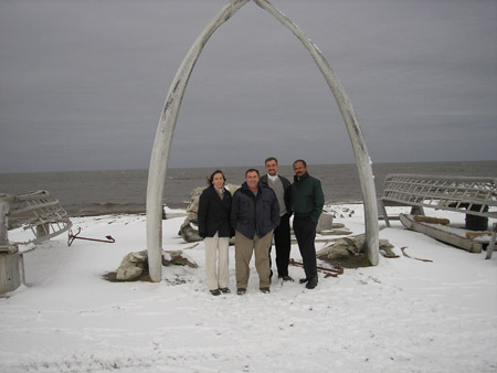 200th celebration greetings from the beach in Barrow in NOAA's
National Weather Service Alaska Region. With 656,425 square miles, Alaska is one-fifth the size of the entire U.S. The National Weather Service Alaska has 225 staff in the
following offices: Alaska Region Headquarters, three Weather Forecast Offices, 12 Weather Service Offices, the Alaska Pacific River Forecast Center, the Alaska Aviation Weather Unit,
the Electronics Maintenance Unit, the Center Weather Service Unit, and the West Coast/Alaska Tsunami Warning Center. Shown (from left): Laura Furgione, Jim Jones, Chris Strager,
and Robert Byrd, who were on a fact-finding trip to observe NOAA weather and climate research operations, inspect facilities, and meet with local civic and Native Alaskan Tribal
Leaders to assess NOAA's impact on Barrow and the North Slope Borough.
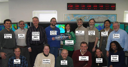 This postcard arrived from the West Coast/Alaska Tsunami Warning Center in Palmer, where
the NOAA National Weather Service has primary responsibility for providing tsunami warnings to the nation. NOAA's two tsunami warning centers are responsible
for issuing advisories, watches, warnings, and information messages to emergency management personnel and the public in the U.S. Atlantic, Gulf of Mexico, Alaska,
and U.S. West Coast regions and along the British Columbia and Atlantic coasts of Canada. Shown (top, from left): Michael Burgy, John Carrick, Brig Gen David L.
Johnson USAF (Ret.), NOAA Assistant Administrator for Weather Services and Director, NOAA's National Weather Service, Justin Ferris, Laura Furgione, Paul Whitmore,
David Hale, Paul Huang, Bruce Turner. Shown (bottom, from left): Bill Knight, Heather Crowley, Guy Urban, Chris Strager, Cindi Preller, Kandis Boyd.
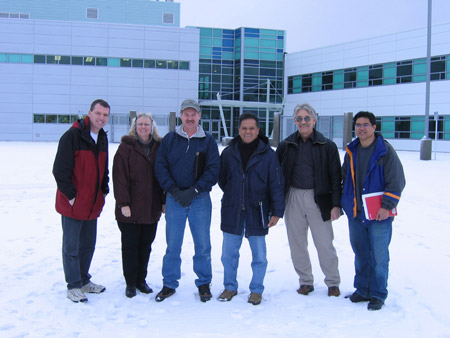 Greetings arrived from the project inspection team outside of the newly constructed
Ted Stevens Marine Research Institute in Juneau, Alaska. The new National Marine Fisheries Service science and research institute is the new home of the
significantly upgraded Alaska Fisheries Science Center's Auke Bay Laboratories. Major fishing industries, state and federal fishery regulators, and
international treaty bodies depend on Auke Bay's broadly used information about fish stocks, fish habitats, and the chemistry of marine environments.
The upgraded lab enables NOAA to expand into critical research areas, including work aimed at understanding species-specific physiological responses
to likely consequences of changing climate. With such understanding, NOAA can develop models to forecast the population, community and ecosystem effects of
these responses and develop scenarios to forecast the socio-economic consequences. Shown (from left): Tom Martin, Judi Jzyk, Mark Eberling, Rino Balatbat,
Ken Bircher, and Tino Escalona.
 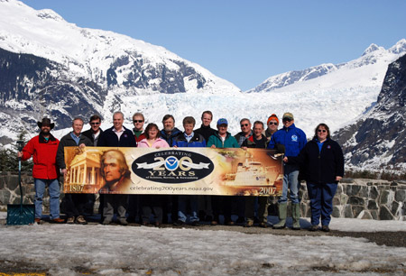 Whether it was a coincidence or in recognition of NOAA's 200th celebration, Juneau was
hit with a record-breaking 200 inches of snow this winter. The lack of roads throughout the Alaska panhandle archipelago forced residents to rely on the
highly weather-dependent services of air carriers and marine vessels to transport people and goods. NOAA's National Weather Service Forecast Office in
Juneau played a key role in protecting lives and property during southeast Alaska's winter, which included avalanches, 100-mile per hour winds, and
50-foot waves. Dedicated NOAA technicians kept remote weather observing stations working throughout the long dark harsh winter. Shown (from left):
Rick Fritsch, Tom Ainsworth, Michael Mitchell, Paul Shannon, Mike Rehbein, Kimberly Vaughan, James Truitt, Kim Custer, Paul Suffern, Art Puustinen,
John Lindsey, Carl Dierking, Bob Tschantz, Joel Curtis, and Ursula Jones.
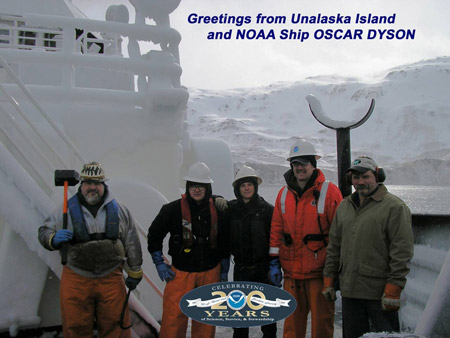 Frozen spray coats OSCAR DYSON, shown here preparing to anchor in Makushin Bay, Alaska, upon completion of the
Bogoslof fisheries survey in the Aleutian archipelago. The ship is working in concert with NOAA Ship MILLER FREEMAN, which is anchored nearby. The two
vessels entered the bay in order to "break ice" off the superstructure and calibrate their scientific echosounders. Enabling scientists to correlate
data acquired by the old and new ships, the calibration is necessary before the 40-year-old MILLER FREEMAN goes out of service. Shown (from left):
Rick Saladin, Patrick Kriegh, Travis Long, Nathan Thomas, and Bruce Knoepke.
 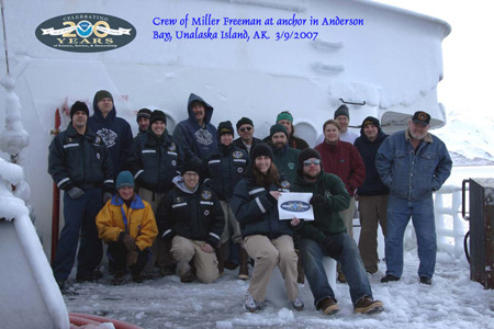 While conducting echo integration-trawl surveys of the abundance and distribution
of walleye pollock in one of the world's largest fisheries near the Aleutian Islands of Umnak and Unalaska, NOAA Ships MILLER FREEMAN and OSCAR DYSON experienced heavy
icing conditions. A low pressure system centered in northern Gulf of Alaska and a high pressure system in the eastern Bering Sea created bitterly cold northerly winds.
Both ships headed for Unalaska to escape freezing sea spray and brief relief from the pounding seas. Braving the cold for a 200th celebration photo are (from left):
Mark Boland, Jesse Duncan, Taina Honkalehto, Kevin Veitch, Jennifer King, David Strausz, Kirk Perry, Laura Gallant, Steve Bus, Lindsey Waller, Phil White, Matt Faber,
Kris Mackie, Kathy Hough, Don Jones, Matt Davis, and Russell Van Dyke.
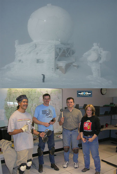 Hunkering down from the wind at the 7,600-foot summit of Mt. Ashland, Oregon,
Warren Matt Wymore, electronics technician at NOAA's National Weather Service Weather Forecast Office in Medford, Oregon, is on-site to ensure the dopplar radar there
remains operational. Warren and electronics technicians (bottom photo, from left) David Kauwe, Darren Dixon, Warren, and Nancy McGlothlan travel to the site by
truck-sized snowcat or snowmobile nine months each year. "The trip," they say, "is not for the faint hearted." From the rain forest of the Southern Oregon coast to the
high desert of southeast Oregon and northeast California, radar stretches across two states, with rugged terrain varying from sea level to over 14,000 feet.
 Channel Islands National Marine Sanctuary dive team members are shown conducting a REEF fish survey in
the cold dark waters off East Anacapa Island near the coast of California. REEF, which refers to the Reef Environmental Education Foundation, engages divers in the
conservation of marine habitats, primarily through the Fish Survey Project developed with guidance from NOAA's Southwest Fisheries Science Center. Dive team members
shown (from left): Chris Mobley, Laura Francis, John Brooks, Danielle Lipski, Rocio Lozano-Knowlton, and (behind the camera) Robert Schwemmer. In 1854, the U.S. Coast
Survey completed a chart of East Anacapa Island that included a sketch by William B. McMurtrie. The final copper plate etching was completed by James McNeill Whistler
who, in his unconventional style, added two flocks of birds in flight. During his short employment with the Coast Survey, Whistler was described as being "outrageous,
unconventional, original, monumentally egotistical, and highly talented."
 For more than six years, the Southwest Fisheries
Science Center has been studying endangered coho salmon and steelhead in coastal California's Santa Cruz Mountains. With an emphasis on ecology, population dynamics,
and genetics, tagged fish are providing insight on local adaptation and biology. Juvenile growth, diet, and movements are monitored in the upper watershed and estuary
along with the ocean survival of fish reared in each habitat. Since fish tags surfaced recently in a nearby gull colony, efforts are underway to assess local bird
predation levels on fish. Sean Hayes (left) holds a female about to head out to sea with an archival tag. Andy Jones and Sarah Rick hold adults about to be released
upstream to begin their spawning run.
 To gain a better understanding of customer needs, National Weather Service
forecasters from the Medford, Oregon Weather Forecast Office, hosted by the U.S. Coast Guard Lifeboat Station Coos Bay, recently experienced waves and hazardous bar
crossing conditions, bobbing for about an hour between jetties and the near shore. By that time, they had new insight into producing better marine forecasts – and
their complexions were infused with shades of green. Shown (from left): Ryan Sandler, Frederic Bunnag, Mike W. Johnson, Katie Burtis, and Sven Nelaimischkies.
 The National Weather Service's Mount Holly office (New
Jersey) recently completed a renovation of its operational area, which covers weather, water, and climate forecasts and warnings for New Jersey, Delaware, southeast
Pennsylvania, and northeast Maryland. For their efforts, staff were honored with the February 2007 Team of the Month award in the NOAA National Weather Service Eastern
Region. Shown (rear, from left): Larry Robinson, Michael Gorse, Dean Iovino, Valerie Meola, and Keith Pugh. Shown (front, from left): Michael Conrad, Larry Nierenberg
and Ray Kruzdlo.
 200th celebration greetings from the beach in Barrow in NOAA's
National Weather Service Alaska Region. With 656,425 square miles, Alaska is one-fifth the size of the entire U.S. The National Weather Service Alaska has 225 staff in the
following offices: Alaska Region Headquarters, three Weather Forecast Offices, 12 Weather Service Offices, the Alaska Pacific River Forecast Center, the Alaska Aviation Weather Unit,
the Electronics Maintenance Unit, the Center Weather Service Unit, and the West Coast/Alaska Tsunami Warning Center. Shown (from left): Laura Furgione, Jim Jones, Chris Strager,
and Robert Byrd, who were on a fact-finding trip to observe NOAA weather and climate research operations, inspect facilities, and meet with local civic and Native Alaskan Tribal
Leaders to assess NOAA's impact on Barrow and the North Slope Borough.
 This postcard arrived from the West Coast/Alaska Tsunami Warning Center in Palmer, where
the NOAA National Weather Service has primary responsibility for providing tsunami warnings to the nation. NOAA's two tsunami warning centers are responsible
for issuing advisories, watches, warnings, and information messages to emergency management personnel and the public in the U.S. Atlantic, Gulf of Mexico, Alaska,
and U.S. West Coast regions and along the British Columbia and Atlantic coasts of Canada. Shown (top, from left): Michael Burgy, John Carrick, Brig Gen David L.
Johnson USAF (Ret.), NOAA Assistant Administrator for Weather Services and Director, NOAA's National Weather Service, Justin Ferris, Laura Furgione, Paul Whitmore,
David Hale, Paul Huang, Bruce Turner. Shown (bottom, from left): Bill Knight, Heather Crowley, Guy Urban, Chris Strager, Cindi Preller, Kandis Boyd.
 Greetings arrived from the project inspection team outside of the newly constructed
Ted Stevens Marine Research Institute in Juneau, Alaska. The new National Marine Fisheries Service science and research institute is the new home of the
significantly upgraded Alaska Fisheries Science Center's Auke Bay Laboratories. Major fishing industries, state and federal fishery regulators, and
international treaty bodies depend on Auke Bay's broadly used information about fish stocks, fish habitats, and the chemistry of marine environments.
The upgraded lab enables NOAA to expand into critical research areas, including work aimed at understanding species-specific physiological responses
to likely consequences of changing climate. With such understanding, NOAA can develop models to forecast the population, community and ecosystem effects of
these responses and develop scenarios to forecast the socio-economic consequences. Shown (from left): Tom Martin, Judi Jzyk, Mark Eberling, Rino Balatbat,
Ken Bircher, and Tino Escalona.
  Whether it was a coincidence or in recognition of NOAA's 200th celebration, Juneau was
hit with a record-breaking 200 inches of snow this winter. The lack of roads throughout the Alaska panhandle archipelago forced residents to rely on the
highly weather-dependent services of air carriers and marine vessels to transport people and goods. NOAA's National Weather Service Forecast Office in
Juneau played a key role in protecting lives and property during southeast Alaska's winter, which included avalanches, 100-mile per hour winds, and
50-foot waves. Dedicated NOAA technicians kept remote weather observing stations working throughout the long dark harsh winter. Shown (from left):
Rick Fritsch, Tom Ainsworth, Michael Mitchell, Paul Shannon, Mike Rehbein, Kimberly Vaughan, James Truitt, Kim Custer, Paul Suffern, Art Puustinen,
John Lindsey, Carl Dierking, Bob Tschantz, Joel Curtis, and Ursula Jones.
 Frozen spray coats OSCAR DYSON, shown here preparing to anchor in Makushin Bay, Alaska, upon completion of the
Bogoslof fisheries survey in the Aleutian archipelago. The ship is working in concert with NOAA Ship MILLER FREEMAN, which is anchored nearby. The two
vessels entered the bay in order to "break ice" off the superstructure and calibrate their scientific echosounders. Enabling scientists to correlate
data acquired by the old and new ships, the calibration is necessary before the 40-year-old MILLER FREEMAN goes out of service. Shown (from left):
Rick Saladin, Patrick Kriegh, Travis Long, Nathan Thomas, and Bruce Knoepke.
  While conducting echo integration-trawl surveys of the abundance and distribution
of walleye pollock in one of the world's largest fisheries near the Aleutian Islands of Umnak and Unalaska, NOAA Ships MILLER FREEMAN and OSCAR DYSON experienced heavy
icing conditions. A low pressure system centered in northern Gulf of Alaska and a high pressure system in the eastern Bering Sea created bitterly cold northerly winds.
Both ships headed for Unalaska to escape freezing sea spray and brief relief from the pounding seas. Braving the cold for a 200th celebration photo are (from left):
Mark Boland, Jesse Duncan, Taina Honkalehto, Kevin Veitch, Jennifer King, David Strausz, Kirk Perry, Laura Gallant, Steve Bus, Lindsey Waller, Phil White, Matt Faber,
Kris Mackie, Kathy Hough, Don Jones, Matt Davis, and Russell Van Dyke.
 Hunkering down from the wind at the 7,600-foot summit of Mt. Ashland, Oregon,
Warren Matt Wymore, electronics technician at NOAA's National Weather Service Weather Forecast Office in Medford, Oregon, is on-site to ensure the dopplar radar there
remains operational. Warren and electronics technicians (bottom photo, from left) David Kauwe, Darren Dixon, Warren, and Nancy McGlothlan travel to the site by
truck-sized snowcat or snowmobile nine months each year. "The trip," they say, "is not for the faint hearted." From the rain forest of the Southern Oregon coast to the
high desert of southeast Oregon and northeast California, radar stretches across two states, with rugged terrain varying from sea level to over 14,000 feet.