
Data Acquisition: Where Would We Be Without It?
Making observations and acquiring data is what NOAA staff do aboard the NOAA fleet. For example, in addition to their regular missions, NOAA ships routinely acquire and transmit weather data every few hours for forecast models. Scientists aboard ships report marine mammal sightings. They take conductivity, temperature, and depth measurements. They take sea surface temperatures and measure the direction of the wind. They provide global positioning system information with these data. These activities take place regardless of whether the ship is focused on fish trawls, seafloor mapping, or ocean exploration expeditions. "This is value added for NOAA that contract ships would never provide unless specifically paid to do so. And this is an extremely important way that we add to the efficiency of our operations," said Rear Admiral Samuel P. De Bow, Jr., director of NOAA's Office of Marine and Aviation Operations and NOAA Commissioned Officer Corps.
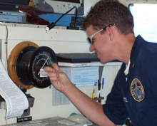
A NOAA Corps officer checks the barometer during a fisheries cruise. NOAA ships routinely acquire weather data and transmit them to shore as "value added" to their primary mission.
NOAA's Office of Marine and Aviation Operations continually looks for new and emerging technologies for data acquisition. According to Rear Admiral De Bow, "We're great at taking technology developed in partnership with the private sector and implementing and testing it aboard our ships and aircraft. We make systems work very well, and the private sector benefits from it. We did this with sonar aboard our hydrographic ships. Currently, we have an ad hoc working group in place to study unmanned aerial systems, like drones, that may eventually be used to fly around hurricanes or work from ships at sea. Our new fisheries survey vessels are using the latest acoustics technologies, and we are benefiting the organization by implementing these new technologies while raising the bar for the world fishing fleet."
The NOAA fleet of today and tomorrow is a critical part of the Integrated Ocean Observing System (IOOS) and the Global Earth Observing System of Systems (GEOSS). IOOS is envisioned as a coordinated national and international network of observations, data management, and analyses that systematically acquires and disseminates data and information on past, present, and future states of the oceans and the nation's coastal areas. GEOSS is an emerging program in which the United States and its international partners will share environmental data acquired through Earth observation systems, such as ships, aircraft, buoys, and satellites. Benefits from the collection and sharing of these data might include safer and more efficient navigation; warnings of natural hazards, such as high winds or rip currents; ecological forecasting, such as harmful algae blooms; and improved hazardous spill response.