
Environmental Modeling at NOAA’s Atlantic Oceanographic and Meteorological Laboratory
NOAA’s Atlantic Oceanographic and Meteorological Laboratory (AOML) is already using environmental modeling for a range of activities. For example, researchers are using models to evaluate the impacts of different resource management strategies, such as various water treatment options. In another case, models are used to predict the number of fish larvae in a particular area. Such information can be used by officials to optimally locate Marine Protected Areas (MPAs). Environmental models are also being used to study the downstream impacts of hurricanes on a local region. In each of these cases, the models are being tailored to the needs of both environmental managers and economists.
The Hybrid Coordinate System Model
AOML oceanographic modeling is done in collaboration with the adjacent Rosenstiel School of the University of Miami, through their Cooperative Institute for Marine and Atmospheric Science. The Rosenstiel School has been a leader in the development of a community Hybrid Coordinate System Model (HYCOM), which is an ocean model. AOML-RSMAS scientists, in collaboration with other investigators (particularly at Florida State University and the Naval Research Laboratory), are developing high-resolution coastal models that work within larger Gulf of Mexico HYCOM models that cover the Gulf of Mexico, the Florida Straits, and the coast of Florida.
Southern Florida Hybrid Coordinate System Model
The Southern Florida Hybrid Coordinate System Model (SoFLA HYCOM) is an environmental model being used to monitor ecologically sensitive shallow areas such as Florida Bay and the Florida Keys Reef Tract, shelf areas such as the South West Florida Shelf, and deep waters found in the Florida Straits. South Florida coastal waters include MPAs within the Florida Keys National Marine Sanctuary and the Dry Tortugas Ecological Reserve.
Observations and modeling are being used to study the effects of human-induced changes, such as those resulting from a project to restore parts of the Everglades, in the context of climate change and climate variability.
The SoFLA HYCOM produces information on currents, sea elevation, salinity, and temperature. This information is incorporated into a comprehensive geographic information system-based decision support system for the Florida Keys and reef tract. This support system also includes socioeconomic layers, vegetation and habitat, legal and administrative boundaries, as well as atmospheric and oceanographic data. The resulting analyses are proving to be an effective management tool and will likely become an integral tool for future management strategies and decisions.
Hurricane Response
In the wake of major hurricanes, it is essential to determine if land-based pollutants and toxins have been flushed into the coastal ecosystem where they can impact fish and plant life or be of danger to human health. AOML researchers, in conjunction with other government and academic agencies, coordinate post-hurricane field observations, satellite analyses, and results from the Gulf of Mexico System Model (GoM HYCOM) to determine the distribution and downstream trajectories of contaminants and toxins. These trajectories are used to determine what coastal areas are at risk of being contaminated.
The very first hurricane response study took place after Hurricane Katrina ravaged many central Gulf coast communities. AOML scientists led a NOAA water quality survey of the Northern Gulf of Mexico aboard the NOAA ship Nancy Foster, working with scientists from across NOAA and academia.
Such research cruises allow for direct sampling of the affected environment and provide data for testing the accuracy of remotely sensed satellite data and model predictions. Together, gathered data allowed NOAA scientists to make five- to seven-day forecasts of pollution exposure for the three-month period following the landfalls of Hurricanes Katrina and Rita.
As coastal populations continue to grow and we continue to live through a several-decade-long period of increased Atlantic hurricane activity, NOAA hopes that environmental managers will be able to count on this type of post-hurricane survey information, to provide the best response possible when future hurricanes strike our coasts. Higher resolution Gulf of Mexico models are now being developed to cover the entire northern Gulf of Mexico coastline and that part of Florida outside the SoFLA HYCOM domain.
Florida Area Coastal Environmental Program
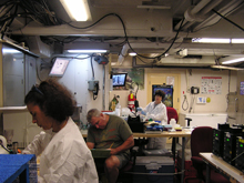
Scientists from AOML and other collaborators hard at work in the Wetlab onboard the Nancy Foster, analyzing data taken during a recent FACE cruise. Click image for larger view.
The Florida Area Coastal Environmental Program (FACE) is a new program at AOML that was developed in response to municipal infrastructure impacts upon the health of Florida coastal ecosystems and the need to bring coordinated expertise to address complex problems.
Through FACE, AOML and its other federal and state agency partners provide unbiased and careful analysis of the physical, chemical, and biological oceanography of coastal areas near sewage outflows, canals, or desalinization plants. FACE applies the most advanced targeted monitoring and analysis techniques available to provide data to high resolution models. Based on these models, NOAA can then provide a requesting utility a detailed report, which becomes a matter of public record and serves as a basis for planning and science-based decision making. The report also provides guidance for infrastructure planning, operation, and permitting and helps determine whether water quality is significantly compromised (and if so where and to what extent) by human-caused (anthropogenic) nutrient sources such as agricultural runoff, storm water discharge, and wastewater disposal.
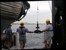
Scientists deploying a Shipek Sediment Sampler from the Nancy Foster during a recent FACE cruise. Click image for larger view.
By better understanding the factors that threaten the health of Florida’s coastal environments, FACE is helping to preserve not only the economic value of Florida’s reefs and beaches, but also the health and well-being of all those that depend on the products of the reefs and beaches, such as fishermen and the tourist industry.
As Florida’s population grows, there will be a greater demand to balance waste water disposal needs with environmental health. The growing population also places a greater demand on freshwater resources. Analyses from the FACE program will help determine when technologies such as oceanic waste water disposal and desalinization are feasible and can effectively be implemented.
It is hoped that this program will be replicated in other U.S. coastal communities, making the most of county, state, and federal resources and expertise to better manage coastal waters.