The Future of Global Navigation Satellite Systems: Anyone, Anywhere, Anytime, Any Accuracy by 2027
"Global navigation satellite system" (GNSS) is the standard generic term for satellite navigation systems that provide autonomous geo-spatial positioning with global coverage. A GNSS allows electronic receivers to determine longitude, latitude, and elevation of the receiver on the Earth's surface. Many of the services provided by NOAA are tied to the use of GNSS, including maintenance of the National Spatial Reference System.
- Introduction
- Portable, Hand-held Devices
- Automobile Navigation
- Homeland Security Applications
- Checking the Weather
- Surveying Work
- Path to the Future
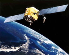
Global Positioning System satellite used for precise positioning and navigation.
The term "global navigation satellite system," or GNSS, generically describes navigation systems that use a network of satellites and a ground-based receiver to calculate the position of the receiver on the Earth's surface. It was not so long ago that satellite navigation systems sounded like something from a James Bond film. However, in the last two decades, rapid advancements in global positioning have made satellite navigation commonplace in everything from cars to cell phones.
Only 11 years have passed since the United States declared full operational capability for the Global Positioning System (GPS). The system, fully named NAVSTAR (NAVigation Satellite Timing and Ranging), is operated by the U.S. Department of Defense and includes 24 satellites that orbit the Earth. The Russian global positioning system (GLONASS) has struggled against funding cuts, but did briefly have a full constellation of satellites just 10 years ago. Additionally, a European GNSS, called Galileo, is under development and a Chinese system, called Compass, was proposed in 2006.
Entire industries have developed around these systems, greatly enhancing the overall performance (accuracy, integrity, etc.) of each GNSS. The overall global benefits gained from each of these systems, relative to their costs and augmentations, must be considered nothing short of incredible.
NOAA's National Geodetic Survey (NGS) is responsible for maintaining the National Spatial Reference System, and GNSS has revolutionized NGS's ability to provide an accurate and frequently updated spatial reference system.
What is perhaps even more incredible is what the next 20 years will bring to the GNSS field. This article considers how the GNSS environment of 2027 might impact everyday citizens and NOAA's ability to deliver services critical to our nation.
Portable, Hand-held Devices
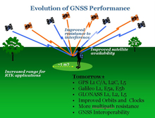
Future users of GNSS will see many more satellites than today with more signals per satellite. Positioning errors will drop to below one meter! Click image for larger view.
Imagine, if you will, a woman named Marie, living and working in the year 2027. When we first encounter Marie, she is on vacation, taking a recreational hike in the Sierra Nevada Mountains. As she climbs to a rise, standing under a thick tree canopy, she pulls out her handheld GNSS receiver and checks her location. Toggling through a variety of reports, she's pleased to see that, unlike signals of the "old days," the strong GNSS signals are penetrating the tree canopy. Her receiver shows the path she's on and approximately how far she's hiked. Her receiver provides her position above sea level, which has been calculated using a NOAA-generated, highly accurate model of the Earth's gravity field. Using tracking signals from GPS, Galileo, and GLONASS, her positional error is about 3.3 feet (1 meter), an improvement over the 33-foot (10-meter) accuracy provided by hand-held devices in 2007.
Nodding with approval, she glances at her friend Jean, who is using her cell phone/GNSS receiver to check their position. Marie is amused to see Jean using one of those "old fashioned" single-frequency units, but Jean's positional accuracy is not much worse than Marie's, as Jean is also receiving ionosphere corrections from a wireless Internet connection. These corrections, provided by NGS and NOAA's Space Environment Center, remove about 23 feet (7 meters) of positioning error normally caused by radio waves passing through the ionosphere. Still, Marie can't help but point out that her own receiver is receiving 10 different positioning signals from three constellations.
Automobile Navigation
Upon finishing her hike, Marie gets in her rental car for the drive to the airport. She flicks on the GNSS navigator (a "navaid") built into her car's dashboard and hears the command "tracking 30 satellites." Startled at this high number, she checks the unit, now remembering that she set it to also track Compass satellites, the Chinese GNSS that was only announced in 2006.
The navigational unit is also tracking the High-accuracy Differential GPS (HA-NDGPS) correction signals. These signals tell Marie what other nearby GNSS receivers are experiencing as far as atmospheric errors and GNSS satellite orbit uncertainties, and help her own GNSS receiver correct for them.
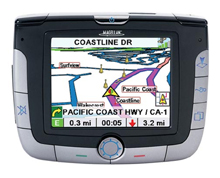
With more satellites in the sky, GNSS based navigation aids will still work in many cities. Click image for larger view.
The navaid informs her that her positional accuracy is four inches (10 centimeters). As she drives along, the navigational unit tracks what lane she is in, occasionally giving her commands such as "move one lane over to prepare for left turn." Marie recalls that back in 2007, early navigational devices in cars could only determine what road a driver was on—not in what lane. She smiles thinking about how far technology has come in the last 20 years!
As she drives through the city, the view of the sky is significantly blocked by tall buildings. Her navaid tells her that it is only tracking six satellites. Luckily, six satellites are enough to fix her position, at least to the level of the correct road, if not the correct lane.
Homeland Security Applications
Marie's drive through the city to reach the airport comes to an abrupt halt when her Homeland-Security-enabled navaid tells her she will be detouring soon, due to a building fire up ahead. Although only an idea 20 years ago, fully integrating the systems of "first responders" into local navigational information databases now allows for this automated detour information.
As she is waiting to turn down the detour, she drives close enough to one of the responding firemen to overhear his shouted conversation with someone on the radio.
"Help me, I'm trapped in the building," says a voice over the radio.

In 1996, the Federal Communications Commission mandated that, by 2005, all cell phones could transmit the caller's position—a program called Enhanced-911, or E-911. Click image for larger view.
"It's Okay sir, you've activated your E-911 cell phone function. We're getting a fix on your position within the building," says the fireman. The fireman turns to his colleagues and shouts: "There's a man trapped on the 3rd floor on the east side of the building. Get a ladder over there now!"
Before she hears more, Marie has turned onto the detour and is heading away from the scene of the fire.
As the time for her flight approaches, she sees the crew getting ready to board, and hears the pilot talking to the co-pilot. "Thankfully when GPS satellite 14 went bad, we got that integrity warning immediately," says the pilot.
"True," says the co-pilot "but honestly, with the LAAS up and running, that airplane could have landed itself with or without one bad satellite." Marie remembers reading that "LAAS" stands for Local Area Augmentation System, and that this system, fully implemented only recently, allows for completely autonomous airplane guidance and landing and airport navigation.
Remembering that she saw an on-screen message about GPS #14 being unreliable on her hand-held yesterday, she's glad that the airline navigation system uses so many checks and augmentations that the impaired satellite had not affected safety at all. Because navigation in 2027 is done purely using space-based GNSS, flight patterns are now direct routes, rather than waypoint-by-waypoint and her flight is faster than in "the old days."Checking the Weather
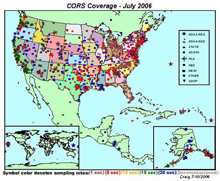
The Continuously Operating Reference Station (CORS) network includes over 1,000 sites now, and with improved infrastructure, the network could grow to 10 times that size. Click image for larger view.
Upon returning home, Marie begins thinking about getting back to work in her job as a land surveyor. She decides to check the weather to see if she will be working in the field or the office tomorrow. Switching on the Weather Channel, she is pleased to see the forecast calls for clear skies. Since meteorologists can use the tens of thousands of Continuously Operating GNSS receivers managed by NOAA to model water vapor, weather prediction is so accurate that Marie does not need to worry much about tomorrow's forecast.
However, the space weather prediction is showing an ionosphere storm will occur in two days. The ability to monitor the ionosphere in real time (already possible in 2007) combined with a sun-looking monitoring satellite (also already possible in 2007) now allows a fairly accurate prediction of ionospheric storms. Such a storm could affect the GNSS signals coming through the atmosphere as well as interrupt the radio communication equipment she uses in the field, so despite the lack of any other weather issues predicted that day, Marie decides that tomorrow may be a good day to spend sometime inside getting some office work done.
Surveying Work
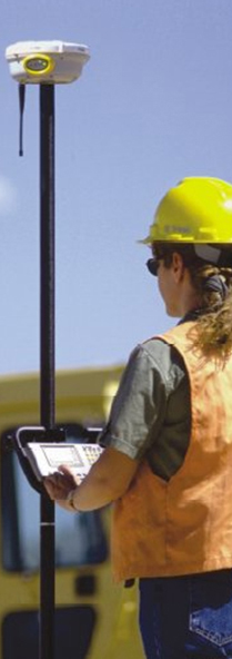
"Marie" using the "rover" in a GNSS RTK survey.
Arriving at work the next day, Marie begins checking out the plans for that day's data collection. Marie works in a state that runs its own Real-Time Kinematic (RTK) GNSS corrector network. This network is where data from a collection of permanently set GNSS receivers with known positions, called "base stations," are accessed by users with a "roving" GNSS receiver to determine a differential position of the rover relative to the fixed "base stations." Because of this network, Marie's surveys will be relative to the state-owned base stations. Although today's work will cross over into another state, this doesn't worry her as she knows that all RTK networks in the United States have been accredited by NOAA as being "NSRS consistent," meaning they will work together seamlessly. With the widespread use of independent RTK networks, it is the duty of NGS to verify that each of them is consistent with the others in providing coordinates that are reported in the National Spatial Reference System (NSRS).
Marie loads up her equipment and heads to the field where she will be performing a topographic survey for the installation of a new tri-state power plant. She flicks on her geodetic-quality RTK equipment, sees that it is tracking four different GNSS systems, as well as the statewide RTK correctors from the network. She gets to work. She moves from point to point, pausing for only a second to get her one-centimeter position before moving on to the next point. As she collects points, a map appears on the computer screen in her truck, indicating the topographic layout being collected.
After a few hours of data collection, Marie is getting ready to leave the field. Before doing so, however, she hits the "submit and check" button on her receiver. She receives a "subsidence warning" from NOAA. Unlike the three-dimensional geodetic control of 2007, in 2027, geodetic control is four-dimensional. Four-dimensional control means that areas of subsidence (land sinking) are well known and warnings as to changing topography are built into surveys. Marie's warning reads: "Note, the area you surveyed has an average subsidence rate of 5 mm / year. Any data collected today will be relative to the new North American Datum (NAVD), with today's date stamped. Future surveys in this region will account for this subsidence rate." Since 2007, the aging NAVD 88 and NAD 83 official datums of the United States were replaced by more accurate, dynamic datums which reflect the variety of changing elements in the world, such as subsidence, tectonics, and sea level rise.
Packing up her things, Marie muses on how nice it is to be living in 2027…Then and Now: Path to the Future
A lot of things need to happen in order to turn Marie’s story into a reality. The developers of the next-generation GNSS systems need to overcome many technical and budgetary challenges.
For the GPS program, a long-term modernization initiative has been under way since 1998, including efforts to add several new civil capabilities to future satellites. Starting in 2005, all new GPS satellites added to the constellation have featured a second civil signal (L2C) for increased user performance. In 2008, a third civil signal (L5) is scheduled to be launched to enhance safety-critical applications. A few years after that, yet another civil signal (L1C) is planned to become available. Adding new capabilities to GPS while ensuring the continuity of existing services is a complex and expensive undertaking. It is also a slow, gradual process, because new satellites do not get launched until older ones drop out of service – often several years later than expected.
In Russia, the GLONASS constellation is still under-populated with satellites after an extended period of neglect in the 1990s. However, renewed political interest in GLONASS modernization has resulted in increased funding and several recent satellite launches. Europe’s Galileo program launched one test satellite in 2005, but political, technical, and funding problems have delayed further progress towards an operational system. Both Russia and Europe are in active discussions with the United States to promote compatibility and interoperability between their systems and GPS. Such technical negotiations will take years to reach fruition in actual hardware.
As for the Compass system, China successfully launched one operational satellite in early 2007, but little is currently known about future plans for the system. No efforts are currently underway to make Compass interoperable with other GNSS services, so there is a long road ahead in that regard.
GPS augmentations are also evolving gradually. The Wide Area Augmentation System (WAAS) has been certified for “Category I” aircraft landing. Similar systems are being fielded in Europe, Japan, and India, paving the way towards a truly global, GPS-based air-safety service. Differential GPS services, already available in dozens of countries for maritime navigation, are moving inland to support terrestrial applications. The national CORS network added its 1,000th site in 2006 and continues to grow at a rapid rate. It is being upgraded to provide faster service to its users.
On the user side, great things are already being done today, and creative minds within the positioning community are continually working with the available GNSS capabilities to make things even better. Innovations like real-time ionosphere corrections, GPS-based two-centimeter positioning within 15 minutes, state-wide RTK, and others are moving forward. As information about future GNSS systems and capabilities becomes available, the user community quickly integrates it into its future plans and technologies.
The combination of improvements to the GNSS constellations, augmentations, and applications will fuel the continued use and usefulness of GNSS for years to come.
Contributed by Dr. Dru A. Smith, NOAA's National Ocean Service
