
The Gulf Stream: Methods of the Investigation and Results of the Research, Appendix No. 10 from the Annual Report of the Coast and Geodetic Survey for 1890
This is the account of John Elliott Pillsbury's curiosity and fascination with the great river in the sea known as the Gulf Stream. It is a memoir and that describes the methods Pillsbury used to investigate this prominent feature of the Atlantic Ocean and test the instrument he devised to measure direction and velocity of ocean currents at any depth. This work was completed while Pillsbury served as executive officer on board the U.S. Coast and Geodetic Survey steamer Blake from 1884-1889.
 Title page
View High-Resolution Image (TIF, 30.4 MB)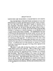 Page 516
View High-Resolution Image (TIF, 820 KB)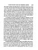 Page 517
View High-Resolution Image (TIF, 905 KB)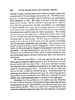 Page 518
View High-Resolution Image (TIF, 885 KB) Page 519
View High-Resolution Image (TIF, 882 KB)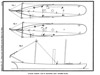 Figure 38
View High-Resolution Image (TIF, 592 KB) Page 520
View High-Resolution Image (TIF, 846 kb)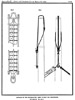 Figure 39
View High-Resolution Image (TIF, 721 KB)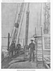 Figure 40
View High-Resolution Image (TIF, 12.3 MB) Page 521
View High-Resolution Image (TIF, 856 KB) Page 522
View High-Resolution Image (TIF, 886 KB)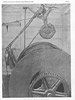 Figure 41
View High-Resolution Image (TIF, 12.3 MB) Page 523
View High-Resolution Image (TIF, 853 KB) Page 524
View High-Resolution Image (TIF, 850 KB)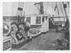 Figure 42
View High-Resolution Image (TIF, 12.0 MB) Page 525
View High-Resolution Image (TIF, 845 KB)
This excerpt includes the title page, pages 516-525, and figures 38-42 from The Gulf Stream: Methods of the Investigation.
View the Flash version.
John Elliott Pillsbury, commanding officer of the USS Blake, an assistant in the U.S. Coast and Geodetic Survey, and a lieutenant in the U.S. Navy, spent part of each of the years 1884-1889 at sea studying the Gulf Stream. The Gulf Stream, a fast-moving current of water flowing from the Gulf of Mexico, through the Straits of Florida, northeast toward Novia Scotia, and extending eastward towards Europe, has enthralled sailors, explorers, and fishermen for centuries. Because of its importance to navigation and commerce, superintendents of the Coast and Geodetic Survey assigned Pillsbury and the Blake to investigate and better understand the Gulf Stream's depth, velocity, temperature, location, and direction.
Exploration History
In this classic work, Pillsbury devotes several chapters to the captivating history of Gulf Stream exploration, crediting Christopher Columbus as its pioneering observer. He covers topics such as Ponce de Leon's personal discovery of the Gulf Stream, speculates on its cause, and discusses the current's influence on the settling of America. He also includes Benjamin Franklin's famous 1770 chart of the Gulf Stream for English captains who, unaware of this ocean current, lost valuable time trying to sail against it in their passages from Europe to North America. (pl. 33, facing p. 488)
The volume captures Pillsbury's and the Blake's successful pioneering efforts for deep-ocean anchoring by using steel wire instead of hemp rope and for measuring the direction and velocity of the Gulf Stream with a current meter that Pillsbury devised in 1876. During the cruises, the Blake anchored in depths up to 2,180 fathoms (over 13,000 feet), the greatest anchoring depth attempted up to that time.
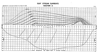
A hallmark of oceanographic work done by the U.S. Coast and Geodetic Survey was attention to detail and a comprehensive tally of data collected during field work. This chart shows the currents of the Gulf Stream measured at 43 stations at different depths. (pl. 51 facing p. 550)
Pillsbury reported in this volume the influence of many factors on the Gulf Stream. He even studied the effect of the moon's transit on the famous current's velocity during the cruises. True to the tradition of previous annual reports of the U.S. Coast and Geodetic Survey and accompanying appendices, Pillsbury in this report described in detail the state-of-the-art oceanographic work carried out from the decks of the Blake.
Descriptive Content
The Gulf Stream is rich in descriptive text, data tables, illustrations, charts, maps, and eloquent prose. One gets a sense of the awe the Gulf Stream inspired in mariners when Pillsbury describes it as "the grandest and most mighty of any terrestrial phenomenon" (p. 472) and further, "[it] is difficult for the mind to grasp the immensity of this great ocean river" (p. 472). The Gulf Stream is still of enormous interest today because of its influence on climate, weather, navigation, fisheries, and ocean circulation.
Who cannot be moved by Pillsbury's evocative passage that so eloquently captures the grandeur of the Gulf Stream:
"Man stands with bowed head in the presence of nature's visible grandeurs, such as towering mountains, precipices, or icebergs, forests of immense trees, grand rivers, or waterfalls. He realizes the force of waves that can sweep away light-houses or toss an ocean steamer about like a cork. In a vessel floating on the Gulf Stream one sees nothing of the current and knows nothing but what experience tells him; but to be anchored in its depths far out of the sight of land, and to see the mighty torrent rushing past at a speed of miles per hour, day after day and day after day, one begins to think that all the wonders of the earth combined can not equal this one river in the ocean" (p. 473).
- Author: John Elliot Pillsbury (1848-1919)
- Date Published: 1891
- Publisher: Government Printing Office
- Location: Washington, DC
- Length: 160 pages
View Complete Rare Book
Related Web Sites
Visible Earth: Gulf Stream's Brightness Temperature from NASA
NOAA's Gulf Stream Finder Project