Fifty Years of NOAA Hurricane Research
For over 50 years, NOAA scientists have applied theoretical studies and computer models and have flown aircraft into hurricanes, all to better understand what makes these storms tick. This research has resulted in a much deeper scientific understanding of hurricanes and improved NOAA hurricane forecasts.
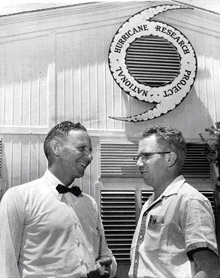
Bob Simpson, Director (on left) and R. Cecil Gentry, Assistant Director (on right) in front of the National Hurricane Research Project headquarters in West Palm Beach, Florida, in April 1956.
Each year, hurricanes batter the East Coast of the U.S. These storms which wreak havoc on all they encounter also provide a wealth of data for NOAA hurricane researchers working to improve hurricane predictions and understand the behavior of these destructive storms.
This article tracks the 50-year history of NOAA hurricane research, starting with the formation of the National Hurricane Research Project in 1956 and continuing through present-day activities of the NOAA Hurricane Research Division.
History of NOAA Hurricane Research
The National Hurricane Project
In April 1956, some 20 scientists and technicians set up shop in a warehouse on the north side of Morrison Air Force Base (now Palm Beach International Airport) in West Palm Beach, Florida. This group set out to tackle a weather problem that had been plaguing mankind for millennia: hurricanes.
Spurred by the devastating hurricane season of 1954, the U.S. Weather Bureau (now NOAA's National Weather Service) formed the National Hurricane Research Project (NHRP) to increase the nation's basic understanding of the structure and mechanics of hurricanes and to put that knowledge to good use by generating better forecasts.
NHRP was placed under the directorship of Robert Simpson, co-inventor of the Saffir-Simpson hurricane damage scale. An unprecedented undertaking for the Bureau, NHRP involved the core of researchers at Morrison Field, meteorologists from a number of other Bureau sections, researchers from various universities, and aircraft and crew on loan from the U.S. Air Force.
Although Navy and Air Force planes had been flying reconnaissance missions into tropical cyclones for over a decade prior to the start of NHRP, little effort had been made to exploit these flights to gain scientific insights. What forecasters needed were better weather instruments, a way to automatically record collected data, and meteorologists onboard the planes to guide the flights to maximize their scientific worth.
NHRP brought these elements together with two B-50 weather reconnaissance planes and one B-47 jet, on loan from the Air Force. These aircraft were outfitted with state-of-the-art (for that time) devices to measure temperature, humidity, and pressure; a punch card machine to save their readings; and a handful of hardy Weather Bureau scientists willing to go aloft to collect the data.
The Project operated out of West Palm Beach for three years as it undertook pioneering work in sketching out the structure, dynamics, and energy budget of hurricanes.
The National Hurricane Center
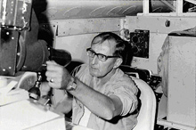
Hurricane researcher Harry Hawkins in the 1960s.
In 1959, NHRP moved to Miami where it merged with the Miami hurricane forecast center, a combination that became known as the NOAA National Hurricane Center. NHRP also obtained its own civilian hurricane hunter aircraft and crews, although they continued a close collaboration with the Air Force and Navy.
Reconnaissance missions and research continued to expand understanding of hurricanes during this period. Beginning in the early 1960s, NHRP scientists were able to use satellites to pinpoint where aircraft needed to fly, eliminating the need to send aircraft on long “fishing expeditions,” in search of tropical disturbances. Satellites also allowed researchers to watch the formation of a hurricane from the very start. New insights into storm genesis were gained from this “top-down” perspective.
The National Hurricane Research Laboratory
In 1964, NHRP became the National Hurricane Research Laboratory (NHRL), a permanently designated Laboratory within the Weather Bureau. Aircraft operations were moved into the Research Flight Facility (which later became the Office of Marine and Aviation Operations in 1970), and the National Hurricane Center name came to be used exclusively by the forecast center.
With the reorganization came a new home: NHRL and the National Hurricane Center moved to the University of Miami Computer Center Building in Coral Gables, Florida, providing access to the University's computer systems. With greater computing power, researchers developed a numerical storm surge model and a statistical hurricane track forecast model that outperformed all existing rivals.
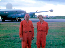
Robert Simpson, original director of the Hurricane Research Project, and his wife Joanne Simpson, head of Project STORMFURY, in Roosevelt Roads, Puerto Rico in 1964. STORMFURY was a government project to investigate the effect of silver iodide to “seed” hurricanes and decrease their intensity. Hurricane modification studies dominated NHRL research for many years.
Over the next several years, the NHRL continued to make great strides in understanding hurricanes. Projects such as STORMFURY that investigated whether it was possible to modify hurricanes to decrease their intensity figured prominently during this period. Research was also conducted on a wide range of topics, from tropical wave dynamics, to air-sea interactions in hurricanes, to rain drop spectra in tropical cyclones.
In the late 1970s, the Lab’s emphasis shifted from hurricane modification research to computer modeling. New radar systems improved field studies, resulting in insights into the fine structure of hurricane rain bands and the process of eyewall replacement.
In 1983, NHRL became the Hurricane Research Division (HRD) of the Atlantic Oceanographic and Meteorological Laboratory.
The Hurricane Research Division: Contributions to Hurricane Research and Understanding
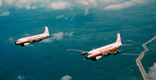
DC-6 aircraft used in hurricane research from 1960 to 1975. DC-6 aircraft participated in the first experiment under the Global Atmospheric Research Project in the summer of 1974. Click image for larger view and full caption.
Today, HRD scientists continue their flights aboard NOAA aircraft, operated by the NOAA Aircraft Operations Center, gathering data and a deeper understanding of all stages of tropical cyclones. Scientists collaborate with researchers in academia, government, and the military in theoretical studies and in the development of operational tools for forecasters at the National Hurricane Center. Years of detailed research and participation in nearly 1,000 hurricane and tropical storm observing flights have yielded tremendous accomplishments. A few HRD advances and accomplishments are highlighted below.
Dropsounde Technology
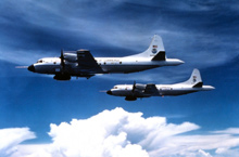
The NOAA WP-3D Orions are versatile turboprop aircraft equipped with a variety of scientific instrumentation, radars, and recording systems for in-situ and remote sensing measurements of the atmosphere, the Earth, and its environment. Obtained as new aircraft from the Lockheed production line in the mid-70s, these robust and well-maintained aircraft have led NOAA's continuing efforts to monitor and study hurricanes and other severe storms, the quality of the atmosphere, the state of the ocean and its fish population, and climate trends.
HRD has continued to research the use of instruments called dropsoundes to study hurricanes. Dropsoundes are instruments deployed from aircraft directly into hurricanes, to measure temperature, humidity, pressure, and winds. In 1982, HRD used dropsoundes to map synoptic-scale winds, which result from pressure differences in surface air masses and drive hurricanes. These data were processed onboard the aircraft and then relayed back to be incorporated into models, resulting in up to 30 percent improvement in forecast accuracy.
More recently, HRD has been using global positioning system (GPS) technology in conjunction with dropsoundes. GPS dropsoundes offer finer vertical resolution, superior thermodynamic sensors, and GPS navigation. This technology could revolutionize understanding of hurricane motion and intensity change and improve hurricane model accuracy.
Stepped Frequency Microwave Radiometer
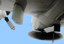
The SFMR instrument is the size of a 27-inch television set and fixed underneath all hurricane hunter aircraft. During the 2005 hurricane season, SFMR data were used in 23 advisories and prompted two special advisories by the National Hurricane Center. In all cases, the data played decisive roles in decisions on current intensity or estimates of intensity change. The data were especially crucial for landfall intensity estimates for Hurricanes Dennis, Katrina, Rita, and Wilma.
The Stepped Frequency Microwave Radiometer (also known as SFMR) uses remote sensing technology to measure hurricane force winds at the sea surface. Wind speed data collected using SFMR in conjunction with GPS dropsoundes are used by the National Hurricane Center to determine accurate peak surface winds (i.e., strongest surface winds observed) and estimate wind radii (i.e., how far the winds extend from the center of the storm).
H*Wind Surface Wind Analysis Maps
Since 1996, HRD has operated the hurricane surface wind analysis project (also known as H*Wind). The purpose of H*Wind is to develop the technology needed to integrate wind data in and around a hurricane from a variety of platforms into a single wind analysis representing all known surface wind speeds in a given hurricane. H*Wind is designed to improve understanding of the extent and strength of the wind field and to improve assessment of hurricane intensity.
Model Development
HRD scientists are continually working to develop and improve the computer models used by forecasters to make accurate hurricane assessments. For example, HRD researchers developed the first ever three-dimensional hurricane model and which became the precursor for all regional hurricane models. HRD also created the Statistical Hurricane Intensity Prediction Scheme (also known as SHIPS). SHIPS uses current and forecasted information such as the sea surface temperatures to determine trends in cyclone intensity.
Just up the East coast in Princeton, New Jersey, NOAA's hurricane computer modelers at the Geophysical Fluid Dynamics Laboratory (GFDL) keep watch on storms brewing in the Atlantic. The GFDL model is one of several used by the National Hurricane Center. In 2005, the GFDL model provided very reliable track guidance throughout the season. GFDL's model also provided improved skill in intensity forecasting, which was especially valuable during Hurricanes Dennis, Katrina, Rita, and Wilma.
Intensity Forecasting Experiment
The main focus of hurricane research in 2005 was the Intensity Forecasting Experiment (also known as IFEX). IFEX is intended to improve understanding and prediction of hurricane intensity change by collecting observations to help evaluate operational numerical models. In 2005, a series of observations into 11 named tropical storms and hurricanes with a total of 81 flights onboard NOAA hurricane aircraft were collected. The IFEX data collected will aid in uncovering the specific conditions conducive to storm development and help in the evaluation of models.
Real-time Data Transmissions
Researchers from HRD designed and implemented a system to use wireless data transfer to allow aircraft data to be sent directly to the National Hurricane Center, delivering data for rapid incorporation into forecast models.
In 2005, data from seven aircraft missions from Hurricane Katrina's south Florida landfall to the Louisiana landfall were transmitted in real-time to the NOAA National Hurricane Center and the NOAA National Centers for Environmental Prediction. These data were used in preparing hurricane warnings and initializing hurricane models. These flights also marked the first delivery of analysis products of hurricane structure using Doppler radar.
Hurricane Research Priorities for the Future
In addition to supporting their operational partners within NOAA and other federal agencies, NOAA HRD researchers will also be focusing on a number of research projects this hurricane season and in the future — namely continued hurricane "intensity" research, new efforts to improve hurricane modeling, and the use of unmanned aircraft in hurricane observations.
Although it is impossible to prevent hurricanes, advances over the last 50 years by the NOAA HRD (and its partners at the Tropical Prediction Center and the Environmental Modeling Center of the NOAA National Centers for Environmental Prediction) are making it easier for coastal residents to properly prepare for and survive the annual Atlantic hurricane season.
