The Geometry of Making Surveys
A survey network is a group of survey points all inter-connected such that they are all in a common coordinate system. The nation's first surveyors needed to establish known positions on the land before they could position survey vessels at sea to measure the water's depth. A consistent and accurate survey network would ensure that the many surveys that would be done along the U.S. coastline fit together properly. It also ensured that land surveys fit together.
Triangulation

A series of triangles used in triangulation surveying is called an “arc of triangulation." Click image for larger view.
Triangulation is a type of surveying that uses the principles of trigonometry to determine positions on the surface of the Earth (i.e., latitude and longitude). If the three angles of a triangle and the length of one side of the triangle are known, the lengths of the other two sides of the triangle can be computed. When a series of triangles with common sides extends along a coastline or elsewhere, distances can be computed for each side of the triangles and carried forward through the triangles from the first triangle to the last.

Example showing a series of quadrilaterals sometimes used in triangulation surveys. Click image for larger view.
A series of triangles extending in an approximate straight line in this fashion is called an "arc of triangulation." A later variation of this method consisted of a chain of four-sided figures with the diagonals as well as the sides of the figures observed. Since each quadrilateral then consisted of four triangles, this provided extra redundancy, or checks, on the survey observations.
Area triangulation provided geodetic control over a region, such as a city or county, or filled in the regions between arcs of triangulation. The area was covered with triangles and therefore also survey points, which were fairly evenly distributed across the area.
The Traverse Method

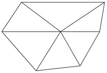
An example of the “area triangulation” method of surveying. Click image for larger view.
Another surveying method used by the Survey of the Coast was the traverse method. A traverse is a series of survey points, often laid out in approximately a straight line. A traverse starts from two known points to provide position and azimuth (direction) for the survey and ends on two known points to check the position and azimuth at the end of the survey. The angles at each point are measured and the distances between adjacent points are measured. The observations can then be used to compute the positions (latitude and longitude) of each of the survey points along the line.

Example illustrating the traverse method of surveying. Click image for larger view.
Traverses often followed existing railroad lines to avoid the costly construction of towers. As with triangulation, towers were often needed in other locations to raise the line-of-sight sufficiently to clear trees and other obstructions. Along the railroad right-of-way, the path was already cleared. However, this method was not as accurate as triangulation.
A Connected Network
By means of this triangulation (and traverse) method, all the surveyed points are thus interconnected forming a unified survey network. A survey network was the key to having all topographic (land) and hydrographic (water) surveys based on a common coordinate system, thus ensuring that surveys fit together correctly when they met. Today, we call this survey network the National Spatial Reference System.
