The Foundations of Meteorology
The science of the weather, today known as meteorology, emerged about 500 years ago with the realization that instruments were needed to measure the properties of the atmosphere and increase our understanding of how and when weather patterns would change. Early inventions measured basic environmental indicators – temperature (thermometer), humidity (hygrometer) and atmospheric pressure (barometer). Observers diligently recorded measurements using these devices, and realizing that data were needed from higher in the atmosphere, began flying instruments on kites in the late 19th century.
Related technological advancements further enhanced our understanding of the atmosphere. For example, the invention of the telegraph in 1843 allowed for routine transmission of weather observations to and from observers stationed across the country. Using this data, crude weather maps were drawn and surface wind patterns and storm systems could be identified and studied on much larger time and space scales.
During the 1940s, measuring meteorological conditions at upper levels of the atmosphere became possible. Instruments used to measure temperature, humidity, and pressure were placed on balloons and released into the atmosphere. Winds at upper levels of the atmosphere were measured by tracking the balloons. These instrument systems, called radiosondes, allowed meteorologists to analyze the atmosphere in three dimensions and greatly improved our understanding of atmospheric processes.

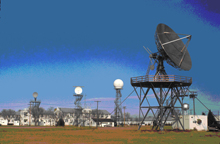
Radar systems, like the WSR-57 shown above, provide valuable information about the location and intensity of storms. Click image for larger view.
In the 1950s, the development of high speed computers greatly enhanced meteorological capabilities. Computer models were developed to recreate the physical processes of the atmosphere and predict its future behavior. Computers were also used to analyze and graphically represent meteorological variables such as temperature, humidity, wind speed and direction, and atmospheric pressure that are measured at thousands of weather stations all over the Earth.
Remote sensing tools, such as radar and satellites, first appeared in the 1950s and 1960s. Radar was first used in the 1950's as an instrument to detect, from a distance, where precipitation was occurring. The first satellite was launched in 1960, providing unprecedented data that has been critical in improving our knowledge of all weather systems. Collecting data from satellites marked the beginning of the age when weather information became available globally.
